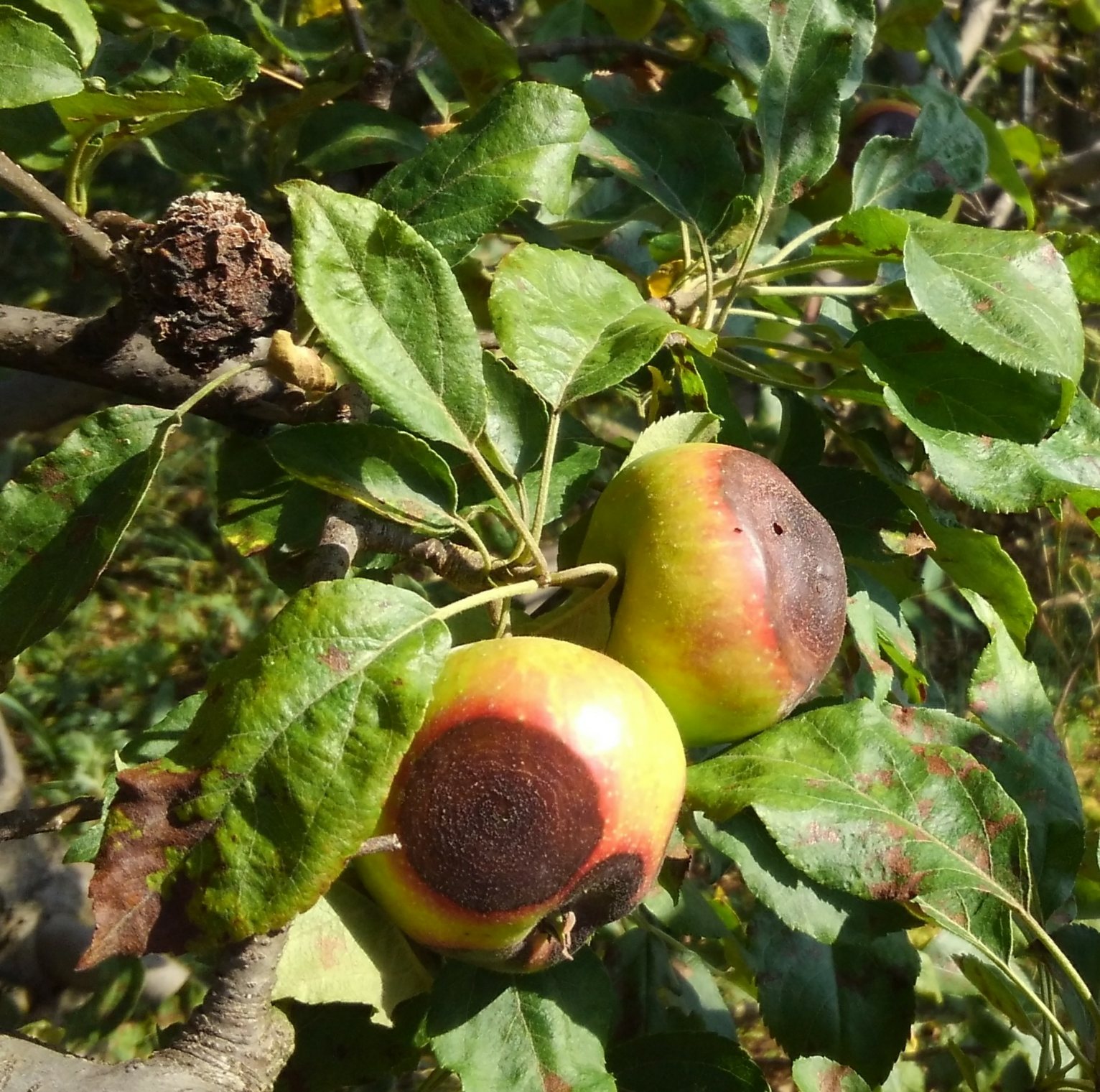
Last night's extended wetting came to 15 hours with 60-70° temperatures and 0.06 in. rain. This wetting favored scab and all summer diseases on apples and brown rot on ripening cherries and other stone fruits.
Friday, May 25, 2012
Thursday, May 24, 2012
Infection period May 23-24
Last night's wetting (12 hr at 63° with 0.04 in. rain) qualified as a scab infection period.
This wetting brought the accumulated wetting hours since Apr 18 to 234 hours. In the next couple days it is likely that we will reach the 250 wetting hour threshold for specific treatment against the sooty blotch/flyspeck fungal complex. This would be the second earliest week for reaching this predictive threshold since we began recording this in 1994. Only 2003 was earlier. This signals early summer disease pressure from the sooty blotch/flyspeck fungal complex as well as other "summer diseases" and Alternaria leaf blotch.
As expected, there are early indications of heavy brown rot pressure on ripening cherries.
Wednesday, May 23, 2012
Infection periods May 21-23
Scab infection periods occurred May 21-22 (22 hr at 67°) and May 22-23 (12 hr at 64°). Total rainfall for these two events was 0.26 in. at our AREC but some other areas of Frederick County received considerably more rain volume, especially on the evening of May 22.
These wetting periods at relatively warm temperatures could signal early summer disease pressure. Through this morning we had accumulated 222 wetting hours since Apr 18, rapidly advancing toward the 250 wetting hour threshold for specific treatment against the sooty blotch/flyspeck fungal complex.
Cherry leaf spot symptoms were observed today.
Monday, May 21, 2012
Early season disease update; sooty blotch and flyspeck wetting hour accumulation
A scab and cedar-apple rust infection period occurred May 13-15 (26 hours wet at 61°, 0.4 in. rain). There was still cedar rust inoculum available for foliar infection but galls are now mostly depleted at our AREC. If you have a recurrent cedar-apple rust problem in your orchard, check the cedar galls in your area for remaining inoculum potential with wetting today.
Through May 20 there have been 38 days favorable for powdery mildew infection since spores were first available Mar 19. Secondary scab and mildew infection are heavy on non-treated trees.
Some shoot blight was reported last week, resulting from scattered hail in some areas of Frederick County May 2. These "trauma blight" symptoms appeared near the time predicted by Maryblyt for May 15. Numerous early reports of fire blight have come from areas east of the Blue Ridge and the Roanoke area south. These likely occurred as blossom infection where bloom was open earlier than in the Winchester area.
For purposes of predicting the development of the sooty blotch and flyspeck (SBFS) fungal complex, we record accumulated wetting hours, starting 10 days after petal fall. With the extended bloom period this year, the petal fall date was somewhat subjective, but we have settled on Apr 8 for petal fall. So the start of wetting hour accumulation will be from Apr 18, 20 days ahead of last year and 11 days ahead of 2010. Through this morning we have accumulated 189 wetting hours toward the 250 wetting hour threshold for specific treatment against the SBFS fungal complex.
Friday, May 11, 2012
Scab and rust infection periods May 5 & 8
Wetting periods favorable for scab and cedar-apple rust infection occurred May 5-6 (13 hours wet at 63°,< 0.01 in. rain) and May 8-9 (split wetting, 18 hours at 64°, 0.4 in. rain). There are still plenty of active rust galls giving off inoculum for foliar infection. Fruit are no longer susceptible to rust infection.
Through May 10 there have been 30 days favorable for powdery mildew infection since spores were first available Mar 19.
There was scattered hail in some areas of Frederick County May 2 and fire blight shoot symptoms related to trauma blight infection are predicted to appear May 15.
The above wetting periods were also favorable for scab infection on peaches and nectarines.
Friday, May 4, 2012
Disease update for the weekend
The recent fire blight scenario unfolded not too far off of that shown in the graphic below for Apr 28. Briefly put, based on recorded and predicted temperatures, any day with wetting from May 1 through May 11 is a potential fire blight infection day where flowers persist. There is still susceptible bloom on Romes, York and Nittany, and some other varieties such as Golden Delicious and Gala, some of which may have been initiated in response to frost injury March 27. Some of these days will have wetting from rain or dew; others will have wetting from thinning or maintenance sprays. On May 2 there was scattered hail that may have caused a trauma blight situation in some areas of Frederick County
Powdery mildew pressure remains high this season, with 26 days favorable for infection through Apr 30. With recent warmer temperatures and more rapid shoot growth, secondary infection is evident and foliage susceptibility very high. Shoots showing secondary infection are likely to have infected lateral buds that will become overwintering inoculum sources for next year's mildew epidemic.
Wetting periods at our AREC this week have been close for secondary scab but not quite long enough for cedar-apple rust infection of foliage. Fruit at thinning size are no longer susceptible to cedar or quince rust infection. There is still a lot of inoculum present on cedar rust gall spore horns.
Labels:
Apple scab,
cedar-apple rust,
Fire blight,
Powdery mildew
Saturday, April 28, 2012
Fire blight update
CAUTION: The observations, conditions, and recommendations reported for Winchester, VA are provided as a guide to fire blight risk assessment only for the immediate area of the Virginia Tech AREC located six miles southwest of Winchester. Use of the information reported here for making orchard management decisions outside of that area is not our intent. Fruit producers outside of that area are encouraged to consult their state extension specialists for information similar to that provided here.
FIRE BLIGHT: Above is a cropped graphic from the Maryblyt 7 program. Some cultivars still have some susceptible late bloom. Here is a prediction for trees with lingering bloom. (A month ago, who would have thought that we would see any bloom at Shenandoah Apple Blossom Festival time next weekend?). The temperature and wetting data were current through yesterday afternoon, Apr 27. Predicted weather conditions are shown for Apr 28-May 5. The components of fire blight risk are indicated in the columns labeled B (blossoms open), H (degree hours for epiphytic bacterial populations), W (wetting by rain or dew), and T (average daily temperature 60 F or above). The risk column shows that fire blight infection could have occurred with wetting by dew Apr 20, and with any wetting of late bloom by rain, a spray application, or heavy dew Apr 15-17. After a ten-day decline, risk could again increase to an infective level with wetting May 2-5. In high-risk situations, a protective streptomycin application is recommended ahead of predicted infection and with any spray applications of other materials. Be aware that risks can abruptly increase with unpredicted warmer temperatures and wetting. The BBS and CBS columns are tracking predicted blossom blight symptom (from infection Apr 20) and canker blight symptom appearance, respectively. Those symptoms should begin to appear about May 6. The numbers represent percent of required degree hours for symptom appearance. The weather conditions used in the predictive part of this graphic come from the Weather Channel for Winchester, supplemented by site-specific data from SkyBit Inc.
| (Click on image to enlarge) |
Monday, April 23, 2012
Disease update
It has been mostly wet since Saturday afternoon, Apr 21, with soaking rainfall totaling 0.9 in. Wetting Saturday likely resulted in quince rust infection of unprotected susceptible blossoms and cedar-rust infection of foliage and some fruit; fruitlets which have reached thinning size should be relatively resistant to quince and cedar rust rust infection. Wind direction during the early wetting was mostly from the west and northwest, a warning regarding the cedar tree inoculum source for rust-prone orchards. The current 24+-hr wetting period favors secondary scab.
Secondary powdery mildew lesions were common by Apr 20, evidence of our most active early season disease this year.
The fire blight outlook remains similar to that posted below, but with risk Apr 23-29 now showing as only light or moderate. However there is still susceptible bloom on many cultivars, especially in lower areas where there was frost damage, and there will probably still be some late bloom when temperatures are again warm enough to expect some risk from fire blight (Stay tuned!).
Friday, April 20, 2012
Fire blight update
CAUTION: The observations, conditions, and recommendations reported for Winchester, VA are provided as a guide to fire blight risk assessment only for the immediate area of the Virginia Tech AREC located six miles southwest of Winchester. Use of the information reported here for making orchard management decisions outside of that area is not our intent. Fruit producers outside of that area are encouraged to consult their state extension specialists for information similar to that provided here.
| (Click picture to enlarge) |
Thursday, April 19, 2012
Scab infection period
An apple scab infection period occurred Apr 18-19 with 28-hr wetting at 47-50°F and 0.52 inches of rain. This length of wetting, coupled with the possibility of secondary infection from lesions that resulted from inadeqate protection Mar 24-25 could raise serious secondatry fruit infection issues in the coming month.
Temperatures are slightly lower than those presented in yesterday's Maryblyt graphic but still present a fire blight blossom infection threat for today.
Labels:
Apple scab,
Fire blight
Wednesday, April 18, 2012
Fire blight and apple scab forecast
CAUTION: The observations, conditions, and recommendations reported for Winchester, VA are provided as a guide to fire blight risk assessment only for the immediate area of the Virginia Tech AREC located six miles southwest of Winchester. Use of the information reported here for making orchard management decisions outside of that area is not our intent. Fruit producers outside of that area are encouraged to consult their state extension specialists for information similar to that provided here.
FIRE BLIGHT: Above is a cropped graphic from the Maryblyt 7 program. Many cultivars still have much susceptible bloom. Here is a prediction for trees with first bloom open Monday, March 23, 2012. The temperature and rainfall data are current through this morning, Apr 18. Predicted weather conditions are shown for Apr 18-22. The components of fire blight risk are indicated in the columns labeled B (blossoms open), H (degree hours for epiphytic bacterial populations), W (wetting by rain or dew), and T (average daily temperature 60 F or above). The risk column shows that fire blight infection could have occurred with any wetting from rain, a spray application, or heavy dew Apr 15-17. After one-day breaks today and Apr 20, risk will again return to an infective level tomorrow, Apr 21-22. In high-risk situations, a protective streptomycin application is recommended ahead of predicted infection and with any spray applications of other materials. Be aware that risks can abruptly increase with unpredicted warmer temperatures and wetting. This graphic will be updated Apr 20. The weather conditions used in the predictive part of this graphic come from the Weather Channel for Winchester, supplemented by site-specific data from SkyBit Inc.
Also, today's wetting could result in a secondary apple scab infection period if it remains wet into tonight.
| (Click picture to enlarge) |
FIRE BLIGHT: Above is a cropped graphic from the Maryblyt 7 program. Many cultivars still have much susceptible bloom. Here is a prediction for trees with first bloom open Monday, March 23, 2012. The temperature and rainfall data are current through this morning, Apr 18. Predicted weather conditions are shown for Apr 18-22. The components of fire blight risk are indicated in the columns labeled B (blossoms open), H (degree hours for epiphytic bacterial populations), W (wetting by rain or dew), and T (average daily temperature 60 F or above). The risk column shows that fire blight infection could have occurred with any wetting from rain, a spray application, or heavy dew Apr 15-17. After one-day breaks today and Apr 20, risk will again return to an infective level tomorrow, Apr 21-22. In high-risk situations, a protective streptomycin application is recommended ahead of predicted infection and with any spray applications of other materials. Be aware that risks can abruptly increase with unpredicted warmer temperatures and wetting. This graphic will be updated Apr 20. The weather conditions used in the predictive part of this graphic come from the Weather Channel for Winchester, supplemented by site-specific data from SkyBit Inc.
Also, today's wetting could result in a secondary apple scab infection period if it remains wet into tonight.
Labels:
Apple scab,
Fire blight
Monday, April 16, 2012
Fire blight update
CAUTION: The observations, conditions, and recommendations reported for Winchester, VA are provided as a guide to fire blight risk assessment only for the immediate area of the Virginia Tech AREC located six miles southwest of Winchester. Use of the information reported here for making orchard management decisions outside of that area is not our intent. Fruit producers outside of that area are encouraged to consult their state extension specialists for information similar to that provided here.
FIRE BLIGHT: Above is a cropped graphic from the Maryblyt 7 program. Many cultivars still have much susceptible bloom. Here is a prediction for trees with first bloom open Monday, March 23, 2012. The temperature and rainfall data are current through Apr 16. Predicted weather conditions are shown for Apr 17-21. The components of fire blight risk are indicated in the columns labeled B (blossoms open), H (degree hours for epiphytic bacterial populations), W (wetting by rain or dew), and T (average daily temperature 60 F or above). The risk column shows that fire blight infection could have occurred with brief showers Apr 14-15 and could again be triggered Apr 17 by wetting from rain, a spray application, or heavy dew. After cooler temperatures Apr 18, infection conditions could again exist Apr 19. In high-risk situations, a protective streptomycin application is recommended ahead of predicted infection and with any spray applications of other materials. Be aware that risks could increase with unpredicted warmer weather and wetting. This graphic will be updated Apr 18. The weather conditions used in the predictive part of this graphic come from the Weather Channel for Winchester, supplemented by site-specific data from SkyBit Inc.
| (Click to enlarge) |
Labels:
Fire blight
Fire blight update for today and tomorrow
The Maryblyt graphic will be updated later today, but conditions remain essentially as predicted for today and tomorrow: blossom infection could result with wetting from rain, a spray application, or heavy dew, triggering infection Apr 15-17. In high-risk situations, a protective streptomycin application is recommended ahead of predicted infection and with any spray applications of other materials.
Labels:
Fire blight
Friday, April 13, 2012
Scab and fire blight update
Scab lesions were observed today on unprotected trees at our AREC. This means there is a potential for secondary infection with the next significant wetting period.
CAUTION: The observations, conditions, and recommendations reported for Winchester, VA are provided as a guide to fire blight risk assessment only for the immediate area of the Virginia Tech AREC located six miles southwest of Winchester. Use of the information reported here for making orchard management decisions outside of that area is not our intent. Fruit producers outside of that area are encouraged to consult their state extension specialists for information similar to that provided here.
FIRE BLIGHT: Above is a cropped graphic from the Maryblyt 7 program. Although some cultivars have reach petal fall of early bloom, many still have much susceptible bloom and a prolonged bloom period is expected. Here is a prediction for trees with first bloom open Monday, March 23, 2012. The temperature and rainfall data are current through this morning, Apr 13. Predicted weather conditions are shown for Apr 13-19. The components of fire blight risk are indicated in the columns labeled B (blossoms open), H (degree hours for epiphytic bacterial populations), W (wetting by rain or dew), and T (average daily temperature 60 F or above). After going through 11 days of light to moderate blossom blight risk, the risk column shows that risk of fire blight infection will increase with warmer temperatures through this weekend and into next week. For infection to be predicted, wetting must occur after the EIP (epiphytic infection potential) reaches 100 or higher and there must be wetting. Wetting from rain, a spray application, or heavy dew would trigger infection Apr 15-16, and infection conditions are predicted with wetting for Apr 17 and 19. In high-risk situations, a protective streptomycin application is recommended ahead of predicted infection and with any spray applications of other materials. This graphic will be updated Apr 16. The weather conditions used in the predictive part of this graphic come from the Weather Channel for Winchester, supplemented by site-specific data from SkyBit Inc.
CAUTION: The observations, conditions, and recommendations reported for Winchester, VA are provided as a guide to fire blight risk assessment only for the immediate area of the Virginia Tech AREC located six miles southwest of Winchester. Use of the information reported here for making orchard management decisions outside of that area is not our intent. Fruit producers outside of that area are encouraged to consult their state extension specialists for information similar to that provided here.
| (Click to enlarge image) |
FIRE BLIGHT: Above is a cropped graphic from the Maryblyt 7 program. Although some cultivars have reach petal fall of early bloom, many still have much susceptible bloom and a prolonged bloom period is expected. Here is a prediction for trees with first bloom open Monday, March 23, 2012. The temperature and rainfall data are current through this morning, Apr 13. Predicted weather conditions are shown for Apr 13-19. The components of fire blight risk are indicated in the columns labeled B (blossoms open), H (degree hours for epiphytic bacterial populations), W (wetting by rain or dew), and T (average daily temperature 60 F or above). After going through 11 days of light to moderate blossom blight risk, the risk column shows that risk of fire blight infection will increase with warmer temperatures through this weekend and into next week. For infection to be predicted, wetting must occur after the EIP (epiphytic infection potential) reaches 100 or higher and there must be wetting. Wetting from rain, a spray application, or heavy dew would trigger infection Apr 15-16, and infection conditions are predicted with wetting for Apr 17 and 19. In high-risk situations, a protective streptomycin application is recommended ahead of predicted infection and with any spray applications of other materials. This graphic will be updated Apr 16. The weather conditions used in the predictive part of this graphic come from the Weather Channel for Winchester, supplemented by site-specific data from SkyBit Inc.
Labels:
Apple scab,
Fire blight
Thursday, April 12, 2012
Fire blight on the horizon
CAUTION: The observations, conditions, and recommendations reported for Winchester, VA are provided as a guide to fire blight risk assessment only for the immediate area of the Virginia Tech AREC located six miles southwest of Winchester. Use of the information reported here for making orchard management decisions outside of that area is not our intent. Fruit producers outside of that area are encouraged to consult their state extension specialists for information similar to that provided here.
FIRE BLIGHT: Above is a cropped graphic from the Maryblyt 7 program. Although some cultivars have reach petal fall of early bloom, many still have much susceptible bloom and a prolonged bloom period is expected. Here is a prediction for trees with first bloom open Monday, March 23, 2012. The temperature and rainfall data are current through Apr 11. Predicted weather conditions are shown for Apr 12-19. The components of fire blight risk are indicated in the columns labeled B (blossoms open), H (degree hours for epiphytic bacterial populations), W (wetting by rain or dew), and T (average daily temperature 60 F or above). After going through 11 days of light to moderate blossom blight risk, the risk column shows that risk of fire blight infection will again increase with warmer temperatures through this weekend and into next week. For infection to be predicted, wetting must occur after the EIP (epiphytic infection potential) reaches 100 or higher and there must be wetting.Only wetting is lacking for Apr 15-16 and infection conditions are predicted for Apr 17. In high-risk situations, a protective streptomycin application is recommended ahead of predicted infection. This graphic will be updated Apr 13. The weather conditions used in the predictive part of this graphic come from the Weather Channel for Winchester, supplemented by site-specific data from SkyBit Inc.
| (Click to enlarge image) |
FIRE BLIGHT: Above is a cropped graphic from the Maryblyt 7 program. Although some cultivars have reach petal fall of early bloom, many still have much susceptible bloom and a prolonged bloom period is expected. Here is a prediction for trees with first bloom open Monday, March 23, 2012. The temperature and rainfall data are current through Apr 11. Predicted weather conditions are shown for Apr 12-19. The components of fire blight risk are indicated in the columns labeled B (blossoms open), H (degree hours for epiphytic bacterial populations), W (wetting by rain or dew), and T (average daily temperature 60 F or above). After going through 11 days of light to moderate blossom blight risk, the risk column shows that risk of fire blight infection will again increase with warmer temperatures through this weekend and into next week. For infection to be predicted, wetting must occur after the EIP (epiphytic infection potential) reaches 100 or higher and there must be wetting.Only wetting is lacking for Apr 15-16 and infection conditions are predicted for Apr 17. In high-risk situations, a protective streptomycin application is recommended ahead of predicted infection. This graphic will be updated Apr 13. The weather conditions used in the predictive part of this graphic come from the Weather Channel for Winchester, supplemented by site-specific data from SkyBit Inc.
Labels:
Fire blight
Sunday, April 8, 2012
Fire blight risk remains low-moderate
Fire blight risk has been low the past four days and should remain low to moderate with cool predicted temperatures through Friday. But risk should return to high with warmer weather predicted for this coming weekend. The fire blight outlook will be updated Apr 11. Expect a rather long bloom period this year, and later susceptibility.
Monday, April 2, 2012
Fire blight outlook for this week
CAUTION: The observations, conditions, and recommendations reported for Winchester, VA are provided as a guide to fire blight risk assessment only for the immediate area of the Virginia Tech AREC located six miles southwest of Winchester. Use of the information reported here for making orchard management decisions outside of that area is not our intent. Fruit producers outside of that area are encouraged to consult their state extension specialists for information similar to that provided here.
FIRE BLIGHT: Above is a cropped graphic from the Maryblyt 7 program. With many cultivars with bloom open, and more bloom opening gradually over the next several days, here is a prediction for trees with first bloom open Monday, March 23, 2012. The temperature and rainfall data are current through Monday morning, Apr 2. Predicted weather conditions are shown for Apr 2-5. The components of fire blight risk are indicated in the columns labeled B (blossoms open), H (degree hours for epiphytic bacterial populations), W (wetting by rain or dew), and T (average daily temperature 60 F or above). Based on predicted temperatures and wetting, the risk column shows that risk of fire blight infection will be mostly low or moderate through Apr 5, and actually for several days beyond that. (It appears that we will be having a prolonged bloom period). For infection to be predicted, wetting must occur after the EIP (epiphytic infection potential) reaches 100 or higher. Note there had been an earlier threat of fire blight on apples at our AREC last weekend, but temperatures fell about 3 degrees cooler than would have been required, based on bloom first open Mar 23. For pears which had been in bloom earlier in the week, or apples in areas with bloom open Mar 22, infection would have been possible with wetting Mar 24. In high-risk situations, a protective streptomycin application is recommended ahead of predicted infection. This graphic will be updated later in the week. The weather conditions used in the predictive part of this graphic come from the Weather Channel for Winchester, supplemented by site-specific data from SkyBit Inc.
Labels:
Fire blight
Friday, March 30, 2012
Fire blight outlook
CAUTION: The observations, conditions, and recommendations reported for Winchester, VA are provided as a guide to fire blight risk assessment only for the immediate area of the Virginia Tech AREC located six miles southwest of Winchester. Use of the information reported here for making orchard management decisions outside of that area is not our intent. Fruit producers outside of that area are encouraged to consult their state extension specialists for information similar to that provided here.
FIRE BLIGHT: Above is a cropped graphic from the Maryblyt 7 program. With many cultivars with bloom open, others are at full pink, and more bloom opening gradually over the next several days, here is a prediction for trees with first bloom open Friday, March 23, 2012. The temperature and rainfall data are current through Friday morning, March 30. Predicted weather conditions are shown for March 31-April 3. The components of fire blight risk are indicated in the columns labeled B (blossoms open), H (degree hours for epiphytic bacterial populations), W (wetting by rain or dew), and T (average daily temperature 60 F or above). Based on predicted temperatures and wetting, the risk column shows that risk of fire blight infection will be mostly low or moderate through Apr 3, but higher if wetting occurs with showers Apr 1. For infection to be predicted, wetting must occur after the EIP (epiphytic infection potential) reaches 100 or higher. Note there had been an earlier threat of fire blight on apples at our AREC last weekend, but temperatures fell about 3 degrees cooler than would have been required, based on bloom first open Friday, March 23. For pears which had been in bloom earlier in the week, or apples in areas with bloom open Mar 22, infection would have been possible with wetting Saturday, Mar 24. In high-risk situations, a protective streptomycin application is recommended ahead of predicted infection.
This graphic will be updated April 2, or sooner if significant change warrants it. The weather conditions used in the predictive part of this graphic come from the Weather Channel for Winchester, supplemented by site-specific data from SkyBit Inc.
Labels:
Fire blight
Monday, March 26, 2012
Scab and rust infection period
As predicted Saturday, extended wetting from March 24-26 resulted in scab, quince rust and cedar-apple rust infection periods at our AREC. A split wetting period was recorded with 8 hours of wetting at 61 degrees, followed by four hours of marginal wetting/drying, then 13 more hours of wetting from 55 to 48 degrees and 3 hours of intermittent wetting. An inch of rainfall, early in the wetting period, likely depleted the residual effects of any protective fungicide residues applied before these events. Cedar-apple and quince rust spores were released within four hours of the start of the wetting period Saturday. For the record, wind direction from potential cedar tree rust spore inoculum sources during the spore discharge period, was mostly from the east or northeast.
In areas where rusts are a common problem, it is advised that an SI fungicide be included in the mix to be applied this week for after-infection control of rusts; in areas where scab is resistant to the SIs, other fungicides are advised to be included for after-infection and protective control of scab and suppressive effects on powdery mildew which infected last week and will continue this week.
The threat of fire blight on apples did not materialize at our AREC, with temperatures about 3 degrees cooler than would have been required, based on bloom first open Friday, March 23. For pears which were in bloom earlier in the week, or apples in areas with bloom open Thursday, infection was possible with wetting Saturday. Cool forecasted temperatures should minimize any threat of fire blight for the rest of this week.
Labels:
Apple scab,
cedar-apple rust,
Fire blight,
Mildew,
quince rust
Saturday, March 24, 2012
Threats of fire blight, rusts and scab.
Scab ascospores and rust spores are mature, and there are threats of cedar-apple and quince rusts and scab infection with the forecast of relatively warm, intermittent showers through tomorrow. Where bloom was open yesterday and there was wetting last night, there is also a threat of fire blight infection. Mildew infection occurred with moderate temperatures throughout this past week.
Tuesday, March 20, 2012
Scab infection period
Wetting last night at our AREC gave us less than 0.01 inch of rainfall, but it stayed wet 14 hr at 57-67 degrees, and resulted in our first apple scab infection period of 2012. As noted in yesterday's post below, the spore target was big for many varieties. Other areas of Frederick County had more rainfall. With the relatively warm temperatures, cedar-apple rust and quince rust spores matured quickly, but probably did not infect last night, at least in our situation. Blossoms beyond tight cluster with their bases exposed would be susceptible to quince rust. Also as noted yesterday, mildew spores were available and infection has already occurred. So these constitute the present apple disease control spectrum concerns. But with the way it's going this year, we may be concerned about fire blight on early bloom before we know it.
Labels:
Apple scab,
Mildew,
rusts
Monday, March 19, 2012
It's a new season!!
Apple scab ascospores were first trapped last Friday, March 16, but it was not wet long enough for infection to occur. Today abundant powdery mildew spores are present on emerging infected tissue, as shown below, and conditions are favorable for mildew infection.
Here is a healthy Idared terminal bud on the left; and a mildew-infected terminal bud on right. Mildew spores on emerging leaf tissue (below) are being dispersed for infection today.
Subscribe to:
Posts (Atom)
