
Summer disease pressures remain high, with continued accumulation of wetting hours and a recent extended wetting period at warm temperatures. The extended wetting event was Aug 15-16: 17 hr at 78-70° with 0.24 in. rain. This favored bitter rot, initiated by rain-splashing of conidia, followed by extended wetting at these warm temperatures.
As of Monday, Aug 15, wetting hour accumulations (ACW) at Winchester: at 909 ft elevation, 770 hr (more than 3 times the 250-hr threshold which was reached June 5); at 952 ft elevation, 594 hr; and at the 983 ft elevation, 450 hr ACW.
Accumulated wetting hours in central Virginia are quite similar to Winchester this year: At Tyro, VA as of Aug 15, a sensor placed at the 941 ft elevation had accumulated 777 hr (with the 250-hr threshold reached June 6); the one at 1165 ft. elevation had accumulated 436 wetting hours, and the one 1465 ft. elevation had accumulated 484.
Wednesday, August 17, 2016
Monday, August 1, 2016
Apple summer disease and peach brown rot alert
Recent wetting events totaling more than 3 inches of rain would have depleted any and all fungicide residues available to protect against apple fruit rots and sooty blotch/flyspeck and brown rot on ripening peaches. For the record, July 28-29 we had 17 hr wet at 71-67°, with 1.89 in. rain, and for July 30-31 it was 17 hr wet at 72-67° with 1.43 in. rain.
Wednesday, July 20, 2016
Continued summer disease pressures
Summer disease pressures have advanced at a relatively steady pace over the past two weeks, with several extended wetting periods and continued accumulation of wetting hours. As of Monday, July 18, we were more than 2 weeks past the 250-hr accumulated wetting hour threshold (ACW) for all of the wetness sensors at our AREC, Winchester and for Tyro, VA.
Wetting hour accumulation (ACW) at Winchester: at 909 ft elevation, 555 hr (with the 250-hr threshold reached June 5); at 952 ft elevation, 419 hr (near the threshold); and at the 983 ft elevation, 341 hr ACW. At Tyro, VA as of July 18, a sensor placed at the 941 ft elevation had accumulated 529 hr (with the 250-hr threshold reached June 6); the one at 1165 ft. elevation had accumulated 309 wetting hours, and the one 1465 ft. elevation had accumulated 341 .
At Winchester in the past two weeks we had three significant extended wetting events favorable for SBFS and fruit rot development: July 4-5: 20 hr at 71-67°, with 0.74 in. rain, July 12-13: 13 hr at 77-66° with 0.04 in. rain, and July 16-17: 15 hr at 77-65° with 0.34 in. rain. Bitter rot was observed on apple fruit at Winchester as early as June 22, and all of these recent wetting periods were at temperatures favorable for bitter rot. Specific treatment against the SBFS fungal complex and rot diseases is advised.
We have installed a new, publicly accessible weather station at our AREC in Winchester. The station, which updates hourly, is located near the laboratory building at an elevation of 933 feet. This station is part of the NEWA system, so to access it one can either click on the NEWA weather station locator map, or go to:
http://newa.cornell.edu/index.php?page=weather-station-page&WeatherStation=va_win
A caution about the station is that because it was install after the beginning of this year's wetting hour accumulation period (May 14), it will not be up to date for predictions in the sooty blotch/flyspeck model.
Continued summer disease pressures
Summer disease pressures have advanced at a relatively steady pace over the past two weeks, with several extended wetting periods and continued accumulation of wetting hours. As of Monday, July 18, we were more than 2 weeks past the 250-hr accumulated wetting hour threshold (ACW) for all of the wetness sensors at our AREC, Winchester and for Tyro, VA. Altough the volume of rainfall has not been excessive, shower activity has favored spread of fungal spores for fruit rots such as bitter rot on apples and brown rot on peaches and other stone fruits.
Wetting hour accumulation (ACW) at Winchester: at 909 ft elevation, 555 hr (with the 250-hr threshold reached June 5); at 952 ft elevation, 419 hr (near the threshold); and at the 983 ft elevation, 341 hr ACW. At Tyro, VA as of July 18, a sensor placed at the 941 ft elevation had accumulated 529 hr (with the 250-hr threshold reached June 6); the one at 1165 ft. elevation had accumulated 309 wetting hours, and the one 1465 ft. elevation had accumulated 341 .
At Winchester in the past two weeks we had three significant extended wetting events favorable for SBFS and fruit rot development: July 4-5: 20 hr at 71-67°, with 0.74 in. rain, July 12-13: 13 hr at 77-66° with 0.04 in. rain, and July 16-17: 15 hr at 77-65° with 0.34 in. rain. Bitter rot was observed on apple fruit at Winchester as early as June 22, and all of these recent wetting periods were at temperatures favorable for bitter rot. Specific treatment against the SBFS fungal complex and rot diseases is advised.
We have installed a new, publicly accessible weather station at our AREC in Winchester. The station, which updates hourly, is located near the labooratory building at an elevation of 933 feet. This station is part of the NEWA system, so to access it one can either click on the NEWA weather station locator map, or go directly to:
http://newa.cornell.edu/index.php?page=weather-station-page&WeatherStation=va_win
A caution about the station is that because it was installed after the beginning of this year's wetting hour accumulation period (May 14), it will not be up to date for predictions in the sooty blotch/flyspeck model.
Wednesday, July 6, 2016
Bitter rot observed at Winchester; Sooty blotch and flyspeck thresholds reached at Winchester and Tyro, VA.
For predicting the development of the sooty blotch and flyspeck (SBFS) fungal complex, we record accumulated wetting hours from rainfall or dew, starting 10 days after petal fall. This year we began wetting hour accumulation at Winchester from May 14. As of Monday, July 4, the 250-hr accumulated wetting hour threshold (ACW) has been surpassed at all of the wetness sensors at our AREC and at Tyro, VA.
At Winchester ACW: at 909 ft elevation, 442 hr (with the 250-hr threshold reached June 5); at 952 ft elevation, 341 hr (near the threshold); and at the 983 ft elevation, 280 hr ACW. At Tyro, VA we started wetting hour accumulation May 4, and as of July 4, a sensor placed at the 941 ft elevation had accumulated 426 hr (with the 250-hr threshold reached June 6); the one at 1165 ft. elevation had accumulated 264 wetting hours, and the one 1465 ft. elevation had accumulated 280 wetting hours.
At Winchester in the past two weeks we had three significant extended wetting events favorable for SBFS and fruit rot development: June 23: 9 hr at 66°, with 0.55 in. rain, and June 27-28: 14 hr at 80-72° with 0.08 in. rain, and July 3-4: 17 hr at 68° with 0.02 in. rain. Bitter rot was observed in Honeycrisp apples at Winchester as early as June 22. Specific treatment against the SBFS fungal complex and rot diseases is advised.
Summer disease management should be directed toward the array of potential problems in specific orchard blocks, utilizing protective fungicides for general purposes, but supplementing them with more specifically active fungicides directed at higher disease pressures and special control problems. Expect higher fruit rot pressures where fire blight killed shoots and fruit mummies are present in the trees. For more information on the effectiveness of apple fungicides for management of sooty blotch/flyspeck, Brooks fruit spot, black rot, white rot and bitter rot consult Table 6 (pp. 53-54) in the 2016 Spray Bulletin for Commercial Tree Fruit Growers.
Monday, June 20, 2016
Increasing summer disease pressures
At Winchester last week we had two significant extended wetting events favorable for SBFS and fruit rot development: June 15-16: 11 hr at 76-72°, with 0.46 in. rain, and June 16-17: 15 hr at 69-63° with 1.95 in. rain. Much of this rain came at the beginning of the event, and this volume of rainfall would have depleted much of the protective fungicide residue, leaving the fruit exposed to potential rot infection.
For purposes of predicting the development of the sooty blotch and flyspeck (SBFS) fungal complex, we record accumulated wetting hours from rainfall or dew, starting 10 days after petal fall. This year we began wetting hour accumulation at Winchester from May 14. As of Monday, June 20, accumulated wetting hours (ACW) toward the 250 wetting hour threshold for specific treatment against the SBFS fungal complex were: at 909 ft elevation, 257 hr (with the 250-hr threshold reached June 5); at 952 ft elevation, 248 hr (near the threshold); and at the 983 ft elevation, 218 hr ACW.
At Tyro, VA we started wetting hour accumulation May 4, and as of June 20, a sensor placed at the 941 ft elevation had accumulated 315 hr (with the 250-hr threshold reached June 6); the one at 1165 ft. elevation had accumulated 188 wetting hours, and the one 1465 ft. elevation had accumulated 213 wetting hours.
At both Winchester and Tyro, most of the wetting hour accumulation at the higher elevations has been only with rain events, while accumulation at the lowest elevation has been with dew as well as rain events.
Summer disease management should be directed toward the array of potential problems in specific orchard blocks, utilizing protective fungicides for general purposes, but supplementing them with more specifically active fungicides directed at higher disease pressures and special control problems. Expect higher fruit rot pressures where fire blight killed shoots and fruit mummies are present in the trees. For more information on the effectiveness of apple fungicides for management of sooty blotch/flyspeck, Brooks fruit spot, black rot, white rot and bitter rot consult Table 6 (pp. 53-54) in the 2016 Spray Bulletin for Commercial Tree Fruit Growers.
Tuesday, June 7, 2016
Sooty blotch/flyspeck thresholds reached at Winchester and Tyro; extended wetting events
For purposes of predicting the development of the sooty blotch and flyspeck (SBFS) fungal complex, we record accumulated wetting hours from rainfall or dew, starting 10 days after petal fall. This year we began wetting hour accumulation at Winchester from May 14. As of Monday, June 6, accumulated wetting hours (ACW) toward the 250 wetting hour threshold for specific treatment against the SBFS fungal complex were: at 909 ft elevation, 257 hr (with the 250-hr threshold reached June 5); at 952 ft elevation, 194 hr; and at the 983 ft elevation, 185 hr ACW.
At Tyro, VA we started wetting hour accumulation May 4, and as of June 6, a sensor placed at the 941 ft elevation had accumulated 245 hr (with the 250-hr threshold reached June 6); the one at 1165 ft. elevation had accumulated 173 wetting hours, and the one 1465 ft. elevation had accumulated 200 wetting hours.
The sensors at the higher elevations at both Winchester and Tyro could reach the threshold ACW within the next week or two, and similar accumulations should be expected for the Carroll-Patrick, Roanoke-Botetourt and Rappahannock-Madison fruit production areas.
At Winchester we had two more extended wetting events at relatively warm temperatures favorable for SBFS and fruit rot development and secondary scab infection last week: June 2-3: 19 hr at 75-64°, with 0.3 in. rain, and June 4-5: 16 hr at 75-67°.
Wednesday, June 1, 2016
Extended wetting events May 24-31 and accumulated wetting hours
We had five extended wetting events the last week of May, and temperatures of several of these ranged into the high 60s and 70s, favorable for summer diseases as well as secondary scab infection: May 24, 9 hr wet at 57-50° with 0.04 in. of rain, May 26-27, 12 hr wet at 70-64° with 0.08 in. of rain, May 27-28, 15 hr wet at 73-63° with 0.2 in. of rain, May 29-30, 15 hr wet at 73-61° with 0.04 in. of rain and May 30-31, 12 hr wet at 72-60° with 0.04 in. of rain.
For purposes of predicting the development of the sooty blotch and flyspeck (SBFS) fungal complex, we record accumulated wetting hours from rainfall or dew, starting 10 days after petal fall. This year we have again chosen May 4 as our petal fall date for Winchester, and the start of wetting hour accumulation is from May 14. As of Monday, May 30, accumulated wetting hours (ACW) toward the 250 wetting hour threshold for specific treatment against the SBFS fungal complex were: at 909 ft elevation, 172 hr; at 952 ft elevation, 128 hr; and at the 983 ft elevation, 116 hr ACW.
At Tyro, VA we started wetting hour accumulation May 4, and as of May 30, a sensor placed at 1465 ft. elevation had accumulated 153 wetting hours, the one at 1165 ft. elevation had accumulated 124 wetting hours, and the one placed at 941 ft elevation had accumulated 175 hr.
Mildew-susceptible cultivars are showing considerable secondary infection, a result of the earlier 28 dry weather mildew infection days through May.
Tuesday, May 24, 2016
Transition to summer diseases
We have had extremely cool conditions the first three weeks of May, with temperatures reaching the 80s only one day (May 2) and barely nudging the 70s only five other days. We are now seeing the development of scab and cedar-apple rust lesions from the infection periods outlined in previous posts: Apr 22-23 and Apr 28-May 12. Mildew-susceptible cultivars are showing considerable secondary infection, a result of the earlier 24 dry weather mildew infection days through Apr 25. Two more extended wetting events last week favored secondary scab and moldy core infection and kicked off the early summer disease pressures. These were: May 21, 14 hr wet at 54° with 0.62 in. of rain, and May 21-23, 33 hr wet at 54° with 0.34 in. of rain. (Actually these two could be lumped together, increasing the threat of fruit infection where primary scab was not well-controlled Apr 22-May 5).
Fire blight infection symptoms appeared locally as early as May 9, from infection that occurred Apr 21-26; symptoms from infection May 2-3 are expected later this week. After we reach late bloom in most years, temperatures are warm enough that protection of late bloom is routinely needed. However this year we have gone 19 consecutive days without infection conditions. But this week conditions return to "normal", with temperatures in the 80s increasing the risk (EIP, effective inoculum potential) to an infective level wherever wetting occurs on late bloom remaining into next week. Continue to protect prolonged bloom, especially on newly planted trees, as needed. With the prolonged cool conditions, we are still seeing late bloom on varieties such as Rome three weeks after we would like to be finished thinking about fire blight!
For purposes of predicting the development of the sooty blotch and flyspeck (SBFS) fungal complex, we record accumulated wetting hours from rainfall or dew, starting 10 days after petal fall. This year we have again chosen May 4 as our petal fall date for Winchester, so the start of wetting hour accumulation is from May 14. As of Monday, May 23, accumulated wetting hours (ACW) toward the 250 wetting hour threshold for specific treatment against the SBFS fungal complex were: at 909 ft elevation, 94 hr; at 952 ft elevation, 76 hr; and at the 983 ft elevation, 73 hr ACW.
To those farther south and east of the Blue Ridge, your normal petal fall date would have been a week or more ahead of ours at Winchester, so we have selected Apr 27 as the petal fall date for accumulation of wetting hours by weather stations at Tyro, VA. One of the purposes of having three weather stations at this location was to compare wetting hour accumulation at different elevations, but because many of the early wetting hours were a result of rainfall rather then dew, the early accumulation trend this year is a bit different than in previous years. As of May 23, a sensor placed at 1465 ft. elevation had accumulated 130 wetting hours from May 4, the one at 1165 ft. elevation had accumulated 107 wetting hours, and the one placed at 941 ft elevation had accumulated 133 hr.
Saturday, May 14, 2016
Disease conditions May 8-12
Wet weather disease conditions persisted this week with infection periods each day May 8-12: May 8: 8 hours wet at 52-56° with 0.1 in. of rain; May 9: 15 hr wet with 0.1 in. of rain; May 10: 8 hr at 53° with 0.03 in. of rain; May 10-11: 19 hr at 55° with 0.25 in. of rain; May 11-12: 16 hr at 55° with 0.16 in. of rain. This now totals 13 infection periods in 15 days! Several of these infection periods again involved both scab and rusts.
Hopefully, the fruits of most varieties are now big enough that they have become resistant to quince rust . However, Romes and some other varieties with late bloom where there was frost damage might be the exception. There still is some cedar-apple rust inoculum left that could infect the youngest leaves, but the long wetting periods are now depleting much of the rust inoculum. This week we saw cedar-apple rust lesions developing from infection that occurred Apr 22-23. (Photo by Allen Cochran II below).
With this amount of wetting during the bloom and immediate post-bloom growth stages, moldy core becomes an unusual concern on varieties such as Red Delicious, Fuji, and Cameo. Moldy core is caused by as many as 14 different fungi that invade during the six-week period that the calyx tube stays open, so broad-spectrum residual fungicide protection is the most effective approach to avoiding this problem. Although the recent volume of rain has not been extreme given the number of wetting periods and hours of wetting that we’ve had, but the conditions have made it difficult to maintain adequate protection the past two weeks.
Fire blight: This week we saw fire blight blossom infection symptoms (shown below) on unprotected York apple trees, resulting from infection that occurred about Apr 20-21. Continue to protect prolonged late bloom as needed.
Hopefully, the fruits of most varieties are now big enough that they have become resistant to quince rust . However, Romes and some other varieties with late bloom where there was frost damage might be the exception. There still is some cedar-apple rust inoculum left that could infect the youngest leaves, but the long wetting periods are now depleting much of the rust inoculum. This week we saw cedar-apple rust lesions developing from infection that occurred Apr 22-23. (Photo by Allen Cochran II below).
 |
| Early cedar-apple rust symptoms on York apple leaf. May 10, 2016. |
Fire blight: This week we saw fire blight blossom infection symptoms (shown below) on unprotected York apple trees, resulting from infection that occurred about Apr 20-21. Continue to protect prolonged late bloom as needed.
 |
| Advanced blossom blight symptoms May 10, 2016 |
Sunday, May 8, 2016
Heavy apple scab pressure April 28 -May 7
Last week, following four scab/rust infection periods during April 28 to May 2, we had four more infection periods: May 2-3: 15 hours wet at 65-58°
with 0.1 in. of rain;
May 3-4: 16 hr wet at 66-46° with 0.08 in. of rain; May 4-5: 20 hr at 57-48° with 0.4 in. of rain; May 5-7: 38 hr at 54-48°
with 0.97 in. of rain. This totals eight infection periods in ten days! Several of these infection periods involved both scab and rusts.
Remaining apple blossoms and small fruit may still be susceptible to quince rust so it is prudent to include a sterol-inhibiting fungicide for after-infection rust control in the next fungicide application. Scab and rust lesions from the Apr 22-23 infection period are expected to start appearing this week.
Fire blight: Continue to protect prolonged bloom as needed.
Powdery mildew: We have had 21 dry weather
“mildew infection days” since mildew spores were first available Mar 16.
Monday, May 2, 2016
Recent scab and rust infection periods and fire blight outlook, May 2, 2016
At our AREC in Winchester, we have had four scab or rust infection periods within the past four days. April 28-29: a heavy apple scab and rust infection period: 31 hours at 53-46° with 0.67 in. of rain; Apr 30: 10 hours at 51° with 0.01 in. of rain; Apr 30-May 1: 18 hours at 53° with 0.53 in. of rain; May 1-2: 12 hours at 59° with 0.16 in. of rain. Locally, some of these wetting periods may have been extended by showers or foggy conditions. Apple blossoms and small fruit are still very susceptible to quince rust so it would be prudent to include a sterol-inhibiting fungicide for after-infection rust control in the next fungicide application.

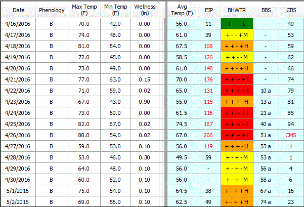
FIRE BLIGHT: Below
is a cropped graphic from the Maryblyt 7 program. Susceptible blossoms are still present on some cultivars. The temperature and rainfall data are current
through Monday morning, May 2. Predicted weather conditions are shown for May 2-7.
The components of fire blight risk are indicated in the columns labeled B
(blossoms open), H (degree hours for epiphytic bacterial populations), W
(wetting by rain or dew), and T (average daily temperature 60 F or above).
Based on predicted temperatures, the risk column shows infection conditions for
Apr 21, 22 and 24-26. The fire blight risk remains high for May 2-4, and
slightly warmer temperatures with wetting could result in infection. For optimum
control, a protective streptomycin application is recommended ahead of
predicted infection, but it can also provide about one day after infection
suppression.

The weather
conditions used in the predictive part of this graphic come from the Weather Channel for Winchester, supplemented by site-specific data from SkyBit Inc. Be
aware that risks on late bloom can change quickly with unpredicted warmer temperatures and
wetting.
Friday, April 29, 2016
Heavy scab and possible rust infection period; fire blight outlook
As of 8 AM April 29 we had recorded a heavy apple scab and possible rust infection period: 30 hours at 53-46° with 0.44 in. of rain. The cedar galls and quince rust cankers are now in "full bloom", producing basidiospore inoculum, and the apple blossoms and small fruit are very susceptible to quince rust. The first 12 hours of wetting at 53° would have have been more favorable for infection by the rusts than the later 18 hours with temperatures down to 46°. With continued sporadic wetting in the 50s likely, it would be prudent to include a sterol-inhibiting fungicide for after-infection rust control in the next fungicide application.
 |
| Maryblyt outlook for Winchester, VA, April 29. |
FIRE BLIGHT: Above
is a cropped graphic from the Maryblyt 7 program. Susceptible flowers are still
open on many cultivars. The temperature and rainfall data are current through
Friday morning, April 29. Predicted weather conditions are shown for April 29-May
2. The components of fire blight risk are indicated in the columns labeled B
(blossoms open), H (degree hours for epiphytic bacterial populations), W
(wetting by rain or dew), and T (average daily temperature 60 F or above).
Based on predicted temperatures, the risk column shows infection conditions for
Apr 21, 22 and 24-26.
Cooler temperatures Apr 29-30 should reduce risks through Apr 30, but predicted warmer temperatures Sunday, May 1 will again increase the risk going into next week. For optimum control, a
protective streptomycin application is recommended ahead of predicted infection,
but it can also provide about one day after infection suppression. Risk can change
quickly with unpredicted warmer temperatures and wetting.
The weather
conditions used in the predictive part of this graphic come from the Weather Channel for Winchester, supplemented by site-specific data from SkyBit Inc. Be
aware that risk can change quickly with unpredicted warmer temperatures and
wetting. The fire blight outlook will be updated Monday, May 2.
Wednesday, April 27, 2016
Fire blight infection conditions today
CAUTION: The
observations, conditions, and recommendations reported for Winchester, VA are
provided as a guide to fire blight risk assessment only for the immediate area
of the Virginia Tech AREC located six miles southwest of Winchester. Use of the
information reported here for making orchard management decisions outside of
that area is not our intent. Fruit producers outside of that area are
encouraged to consult their state extension specialists for information similar
to that provided here.

FIRE BLIGHT:
Above is a cropped graphic from the Maryblyt 7 program. Susceptible flowers are
still open on most cultivars. Here is the prediction for trees with first bloom
open Monday, April 11, 2016. The temperature and rainfall data are current
through Wednesday morning, April 27. Predicted weather conditions are shown for
April 27-May 1. The components of fire blight risk are indicated in the columns
labeled B (blossoms open), H (degree hours for epiphytic bacterial
populations), W (wetting by rain or dew), and T (average daily temperature 60 F
or above). For infection to be predicted, wetting must occur after the EIP
(epiphytic infection potential) reaches 100 or higher, which has been true
since Apr 18. Based on predicted temperatures, the risk column shows infection
conditions for Apr 21-22 and 24-27. (Note that the outlook for Apr 25-26 changed
from the previous post due to unpredicted showers both days). For optimum
control, a protective streptomycin application is recommended ahead of
predicted infection, but it can also provide about one day after-infection
suppression. Predicted cooler conditions after today and through APPLE BLOSSOM
FESTIVAL weekend should reduce risks during this time. (The cooler temperatures
will probably also ensure that a few apple blossoms will be present through the
weekend for those who come to the area looking for them).
The BBS column
is tracking predicted symptom development for the first infection Apr 21. Yesterday
we could already see symptoms from experimental inoculations Apr 18. The CBS
column predicted for the appearance of canker margin symptoms Apr 26, due to
extension of overwintering cankers from last year, and it is now tracking the predicted
appearance of canker blight symptoms when that value reaches 100. Canker blight
cannot be prevented by chemical treatment and the presence of symptoms would
signal build-up of inoculum which could become a factor in the event of a trauma
blight situation due to hail injury, etc.
The weather
conditions used in the predictive part of this graphic come from the WeatherChannel for Winchester, supplemented by site-specific data from SkyBit Inc. Be
aware that risk can change quickly with unpredicted warmer temperatures and
wetting. Unless the outlook changes appreciably form currently predicted
conditions, the fire blight outlook will not be updated until Monday, May 2.
Monday, April 25, 2016
Fire blight and other disease threats this week
CAUTION: The
observations, conditions, and recommendations reported for Winchester, VA are
provided as a guide to fire blight risk assessment only for the immediate area
of the Virginia Tech AREC located six miles southwest of Winchester. Use of the
information reported here for making orchard management decisions outside of
that area is not our intent. Fruit producers outside of that area are
encouraged to consult their state extension specialists for information similar
to that provided here.
 |
| Maryblyt outlook April 25, 2016 |
FIRE BLIGHT:
Above is a cropped graphic from the Maryblyt 7 program. Susceptible flowers are
still open on most cultivars. Here is the prediction for trees with first bloom
open Monday, April 11, 2016. The temperature and rainfall data are current
through Monday morning, April 25. Predicted weather conditions are shown for
April 25-29. The components of fire blight risk are indicated in the columns
labeled B (blossoms open), H (degree hours for epiphytic bacterial
populations), W (wetting by rain or dew), and T (average daily temperature 60 F
or above). For infection to be predicted, wetting must occur after the EIP
(epiphytic infection potential) reaches 100 or higher, which has been true
since Apr 18. Based on predicted temperatures, the risk column shows infection
conditions for Apr 21, 22 and 23 and only wetting is lacking for Apr 25-27. In situations where all other requirements for infection have been
met except wetting, wetting from a maintenance spray application can provide
the wetting trigger for infection to occur. In high-risk situations, a
protective streptomycin application is recommended ahead of predicted
infection. A streptomycin spray remains effective about 3 days in warmer
conditions when it is needed most and can provide about one day after-infection
suppression.
The BBS column
is tracking predicted symptom development for the first infection Apr 21. The
CBS column indicates progression toward the appearance of canker margin
symptoms due to extension of overwintering cankers from last year, which are
predicted to occur when that value reaches 100 Apr 27. Canker advancement
cannot be prevented by chemical treatment at this time and the presence of
symptoms will signal build-up of inoculum which could become a factor in the
event of a trauma blight situation due to hail injury, etc.
The weather
conditions used in the predictive part of this graphic come from the Weather Channel for Winchester, supplemented by site-specific data from SkyBit Inc. Be aware
that risk can change quickly with unpredicted warmer temperatures and wetting.
The fire blight outlook will be updated Wednesday, Apr 27.
OTHER DISEASES: We recorded a 15-hr scab, cedar-apple rust and quince rust infection period Apr 22-23. The infection period was as long as 23 hr in Tyro, VA. Where fungicides were not applied recently enough to cover through this infection event, we suggest ones with after-infection activity for scab and rusts, applied as soon as possible.
 |
| Cedar-apple rust galls with expanded spore horns April 22, 2016. |
Meanwhile, powdery mildew has been by far our most active apple disease so far this year. Mildew is our only "dry weather" disease and we have had 24 infection days since spores were first available March 16. Secondary infection, shown below, has been evident for at least two weeks.
 |
| Secondary powdery mildew infection, Ginger Gold apple. |
Peach leaf curl infection occurred at our AREC as early as March 13. Complete control can be achieved with a single application of an effective fungicide in the dormant season any time from leaf drop in the fall until just before infection occurs with wetting after first bud swell in the spring.
 |
| Peach leaf curl, Turk Mt. Overlook, Skyline Drive, Virginia |
Finally, after the early season we have had this year, we are happy to see peach and apple trees making little fruits at our AREC!
 |
| Shuck-split stage on Redhaven peach, April 22, 2016, |
Friday, April 22, 2016
Current fire blight conditions
CAUTION: The
observations, conditions, and recommendations reported for Winchester, VA are
provided as a guide to fire blight risk assessment only for the immediate area
of the Virginia Tech AREC located six miles southwest of Winchester. Use of the
information reported here for making orchard management decisions outside of
that area is not our intent. Fruit producers outside of that area are
encouraged to consult their state extension specialists for information similar
to that provided here.

FIRE BLIGHT:
Above is a cropped graphic from the Maryblyt 7 program. Susceptible bloom is
open on all cultivars. Here is the prediction for trees where first bloom was open
Monday, April 11, 2016. The temperature and rainfall data are current through
Friday morning, April 22. Predicted weather conditions are shown for April 22-26.
The components of fire blight risk are indicated in the columns labeled B
(blossoms open), H (degree hours for epiphytic bacterial populations), W
(wetting by rain or dew), and T (average daily temperature 60 F or above). For
infection to be predicted, wetting must occur after the EIP (epiphytic
infection potential) reaches 100 or higher, which has been true since Apr 18.
Based on predicted temperatures, the risk column shows infection conditions for Apr 21-24 and Apr 26 and only wetting is lacking for Apr 25. In situations where all other requirements for infection have been met except wetting, wetting from a maintenance spray application can provide the wetting trigger for infection to occur. In high-risk situations, a protective streptomycin application is recommended ahead of predicted infection. A streptomycin spray remains effective about 3 days in warmer conditions when it is needed most and can provide about one day after-infection suppression.
Based on predicted temperatures, the risk column shows infection conditions for Apr 21-24 and Apr 26 and only wetting is lacking for Apr 25. In situations where all other requirements for infection have been met except wetting, wetting from a maintenance spray application can provide the wetting trigger for infection to occur. In high-risk situations, a protective streptomycin application is recommended ahead of predicted infection. A streptomycin spray remains effective about 3 days in warmer conditions when it is needed most and can provide about one day after-infection suppression.
The BBS column
is tracking predicted symptom development for the first infection Apr 21. The
CBS column indicates progression toward the appearance of canker margin
symptoms due to extension of overwintering cankers from last year, which are
predicted to occur when that value reaches 100 Apr 26. Canker advancement
cannot be prevented by chemical treatment at this time and the presence of
symptoms will signal build-up of inoculum which could become a factor in the
event of a trauma blight situation due to hail injury, etc.
The weather conditions used in the predictive part of this graphic come from the Weather Channel for Winchester, supplemented by site-specific data from SkyBit Inc. Be aware that risk can change quickly with unpredicted warmer temperatures and wetting. In high-risk situations, a protective streptomycin application is recommended ahead of predicted infection. The fire blight outlook will be updated Monday, Apr 25.
Wednesday, April 20, 2016
Continued fire blight risk into next week
CAUTION: The
observations, conditions, and recommendations reported for Winchester, VA are
provided as a guide to fire blight risk assessment only for the immediate area
of the Virginia Tech AREC located six miles southwest of Winchester. Use of the
information reported here for making orchard management decisions outside of
that area is not our intent. Fruit producers outside of that area are
encouraged to consult their state extension specialists for information similar
to that provided here.

FIRE BLIGHT:
Above is a cropped graphic from the Maryblyt 7 program. Susceptible bloom is
open on all cultivars. Here is the prediction for trees with first bloom open
Monday, April 11, 2016. The temperature and rainfall data are current through Wednesday
afternoon, April 20. Predicted weather conditions are shown for April 21-25.
The components of fire blight risk are indicated in the columns labeled B (blossoms
open), H (degree hours for epiphytic bacterial populations), W (wetting by rain
or dew), and T (average daily temperature 60 F or above). For infection to be predicted, wetting must occur after the EIP
(epiphytic infection potential) reaches 100 or higher, which is occurring
today, Apr 18. Based on predicted temperatures, the risk column shows high risk
for Apr 18-23 and Apr 25. Infection is indicated with predicted thunderstorms Apr
23. Be aware that in situations where all other requirements for infection have
been met except wetting (Apr 18-22 and 25), wetting from a maintenance spray
application can provide the wetting trigger for infection to occur. In
high-risk situations, a protective streptomycin application is recommended
ahead of predicted infection.
The CBS column
at the right in the graphic indicates progression toward the appearance of
canker margin symptoms due to extension of overwintering cankers from last
year, which would be predicted to occur when that value reaches 100. Canker
advancement cannot be prevented by chemical treatment at this time and the
presence of symptoms will signal build-up of inoculum which could become a
factor in the event of a trauma blight situation due to hail injury, etc.
The weather
conditions used in the predictive part of this graphic come from the WeatherChannel for Winchester, supplemented by site-specific data from SkyBit Inc. Be
aware that risk can change quickly with unpredicted warmer temperatures and
wetting. In high-risk situations, a protective streptomycin application is
recommended ahead of predicted infection. The fire blight outlook will be
updated Friday, Apr 24.
Monday, April 18, 2016
Fire blight active this week!
CAUTION: The
observations, conditions, and recommendations reported for Winchester, VA are
provided as a guide to fire blight risk assessment only for the immediate area
of the Virginia Tech AREC located six miles southwest of Winchester. Use of the
information reported here for making orchard management decisions outside of
that area is not our intent. Fruit producers outside of that area are
encouraged to consult their state extension specialists for information similar
to that provided here.

FIRE BLIGHT:
Above is a cropped graphic from the Maryblyt 7 program. Susceptible bloom is
open on all but late cultivars (Even Rome Beauty clusters are waking up!), and earlier
cultivars are approaching full bloom. Here is the prediction for trees with
first bloom open Monday, April 11, 2016. The temperature and rainfall data are
current through Monday morning, April 18. Predicted weather conditions are
shown for April 18-23. The components of fire blight risk are indicated in the
columns labeled B (blossoms open), H (degree hours for epiphytic bacterial
populations), W (wetting by rain or dew), and T (average daily temperature 60 F
or above). For infection to be
predicted, wetting must occur after the EIP (epiphytic infection potential)
reaches 100 or higher, which is occurring today, Apr 18. Based on predicted
temperatures, the risk column shows high risk for Apr 18-22, with only wetting lacking
as the trigger for fire blight infection these days. Infection is indicated with
predicted showers for Apr 22. Be aware that in situations where all other
requirements for infection have been met except wetting (Apr 18-22), wetting
from a maintenance spray application can provide the wetting trigger for
infection to occur. In high-risk situations, a protective streptomycin
application is recommended ahead of predicted infection.
The CBS column
at the right in the graphic indicates progression toward the appearance of
canker margin symptoms due to extension of overwintering cankers from last
year, which would be predicted to occur when that value reaches 100. Canker
advancement cannot be prevented by chemical treatment at this time and the
presence of symptoms will signal build-up of inoculum which could become a
factor in the event of a trauma blight situation due to hail injury, etc.
The weather
conditions used in the predictive part of this graphic come from the WeatherChannel for Winchester, supplemented by site-specific data from SkyBit Inc. Be
aware that risk can change quickly with unpredicted warmer temperatures and
wetting. In high-risk situations, a protective streptomycin application is
recommended ahead of predicted infection. The fire blight outlook will be
updated Wednesday, Apr 20.
Friday, April 15, 2016
Fire blight outlook for the Winchester area, April 16-22
CAUTION: The
observations, conditions, and recommendations reported for Winchester, VA are
provided as a guide to fire blight risk assessment only for the immediate area
of the Virginia Tech AREC located six miles southwest of Winchester. Use of the
information reported here for making orchard management decisions outside of
that area is not our intent. Fruit producers outside of that area are
encouraged to consult their state extension specialists for information similar
to that provided here.

FIRE BLIGHT:
Above is a cropped graphic from the Maryblyt 7 program. Susceptible bloom is open on most
cultivars. Here is the prediction for trees with first bloom open Monday, April
11, 2016. The temperature and rainfall data are current through Friday afternoon,
April 15. Predicted weather conditions are shown for April 16-22. The
components of fire blight risk are indicated in the columns labeled B (blossoms
open), H (degree hours for epiphytic bacterial populations), W (wetting by rain
or dew), and T (average daily temperature 60 F or above). For infection to be predicted, wetting must occur after the EIP
(epiphytic infection potential) reaches 100 or higher, which is predicted to
occur Apr 18. Based on predicted temperatures, the risk column shows high risk
for Apr 18 and Apr 20-22, and only wetting is lacking as a trigger for
fire blight infection those days. Be aware that in such situations, the wetting by a maintenance spray application can meet the wetting requirement for infection to
occur when the EIP is above 100 and all other requirements for infection have
been met. In high-risk situations, a protective streptomycin application is
recommended ahead of predicted infection.
The CBS column at the right in the graphic indicates progression toward the appearance of canker margin symptoms due to extension of overwintering cankers from last year, which would be predicted to occur when that value reaches 100. Canker advancement cannot be prevented by chemical treatment at this time and the presence of symptoms will signal build-up of inoculum which could become a factor in the event of a trauma blight situation due to hail injury, etc.
The weather
conditions used in the predictive part of this graphic come from the WeatherChannel for Winchester, supplemented by site-specific data from SkyBit Inc. Be
aware that risk can change quickly with unpredicted warmer temperatures and
wetting. In high-risk situations, a protective streptomycin application is
recommended ahead of predicted infection. The fire blight outlook will be
updated Monday, Apr 18.
Wednesday, April 13, 2016
Fire blight outlook for the Winchester area, April 13-18
CAUTION: The
observations, conditions, and recommendations reported for Winchester, VA are
provided as a guide to fire blight risk assessment only for the immediate area
of the Virginia Tech AREC located six miles southwest of Winchester. Use of the
information reported here for making orchard management decisions outside of
that area is not our intent. Fruit producers outside of that area are
encouraged to consult their state extension specialists for information similar
to that provided here.

FIRE BLIGHT:
Above is a cropped graphic from the Maryblyt 7 program. Early bloom is now open on many apple cultivars. Here is the prediction for trees with first bloom open Monday, April
11, 2016. The temperature and rainfall data are current through Wednesday
morning, April 13. Predicted weather conditions are shown for April 13-20. The
components of fire blight risk are indicated in the columns labeled B (blossoms
open), H (degree hours for epiphytic bacterial populations), W (wetting by rain
or dew), and T (average daily temperature 60 F or above). For infection to be predicted, wetting must occur after the EIP
(epiphytic infection potential) reaches 100 or higher.
Based on record temperatures and wetting, the
risk column shows high risk for Apr 11, but the EIP had not yet reached 100 and
would have required max/min temperatures 9 degrees warmer to reach the infective level.
There were occasional blossoms open at our AREC as early as Apr 8, but with the
indicated temperatures, that would have made little difference in the risk
interpretation for Apr 11. With cooler predicted temperatures through the rest
of this week, fire blight risk should remain low to moderate. However, with
warmer predicted temperatures Apr 17-18, the EIP would again approach the
infective level by Apr 18.
The weather
conditions used in the predictive part of this graphic come from the Weather Channel for Winchester, supplemented by site-specific data from SkyBit Inc. Be
aware that risk can change quickly with unpredicted warmer temperatures and
wetting. In high-risk situations, a protective streptomycin application is
recommended ahead of predicted infection. This fire blight outlook will be
updated Friday, April 15.
FUNGAL DISEASES: Powdery mildew remains our most active early season apple disease, with 13 dry weather mildew infection days recorded since March 16. Primary and secondary mildew infection will likely become more evident after we get some consistently warmer growth conditions.
Wednesday, March 30, 2016
Gradual bud movement to pre-pink

We have seen gradual bud movement at Winchester since the previous post on March 18. Above are the same Red Delicious buds that were pictured previously at green-tip stage. They now are showing some color in the pre-pink stage. Most cultivars at our AREC were at tight cluster stage, but will advance more rapidly in the next couple days.
It looks like we are headed for the first 2016 apple scab and cedar-apple and possibly quince rust infection period at our AREC Thursday night and Friday morning Mar 31-Apr 1. Hopefully there has been ample opportunity to protect the developing buds as they moved through the tight cluster stage. Cedar-apple rust galls are plentiful in some areas, even to the point of causing browning of the foliage as shown below.
 |
| Cedar-apple rust galls on eastern red cedar near Winchester, VA |
I noted that we had seen apple powdery mildew conidiospores by March 17, and in the interim we have already recorded 8 mildew infection days. So you might say that, in this Spring Training exercise, the mildew has outscored scab 8-0!
Redhaven peach trees (shown below) are now approaching full bloom.

In-depth meeting March 31:
Finally, this is a reminder that our first In-Depth Meeting of the new season will be held at Alson H. Smith Jr. AREC, 595 Laurel Grove Road, Winchester, VA, starting at 7 PM Thursday, March 31. Following an entomology update by Dr. Chris Bergh, we will address early season disease management issues and end with some recent pathology questions and answers.
Friday, March 18, 2016
It's a new season!

At our AREC we had green tip on Red Delicious (shown above) and other apples March 16 and about 1/4-inch green by March 17. 55 hours of wetting, with discharge of apple scab ascospores, had occurred from March 13-15. This was more than three times the length of wetting required for scab infection where green tissue was exposed, but our buds had not advanced to that stage by that time.
Scab infection was likely in areas where buds were more advanced to the green-tip stage. In Tyro, Virginia, 51 hours of wetting was recorded at temperatures that were about 5 degrees warmer than at Winchester, resulting in more than four times the length of wetting required for scab infection. Apple scab ascospore maturity at green-tip stage is normal and should be expected except in years when buds advance rapidly without any moisture to mature the spores.
Powdery mildew spore production is advanced compared to most years. Typically, buds infected with overwintering mildew are somewhat delayed compared to their healthy counterparts. However, I was surprised to see mildew-infected buds as advanced as healthy ones (upper right, below), and they had an abundance of conidia (below). In contrast to wetting conditions needed for scab infection, powdery mildew is able to infect on dry days with temperatures above 53 degrees F.
 |
| Mildew infected Idared bud, upper right. |
 |
| Mildew conidia on Idared. Winchester, March 17, 2016 |
Cedar-apple rust galls are also ready to produce infective basidiospores with the next warm wetting period, so protective apple fungicides should now be included for mildew and rusts as well as for scab.
 |
| Cedar-apple rust gall ready to produce spores March 16. Virginia Tech AREC, Winchester. |
 |
| Redhaven peach bud development at Virginia Tech AREC, Winchester, March 17, 2016. |
Peach buds (above) were more advanced than apples, and unprotected buds would have been readily susceptible to leaf curl infection with wetting March 13-15. Because spores of the leaf curl fungus are carried on the surface of the tree from the fall to spring, fungicides applied in the fall or during the winter give good protection from leaf curl. Fall applications help to avoid the spring rush to spray before pruning brush is removed from the orchard.
Subscribe to:
Posts (Atom)