Saturday, August 26, 2017

Summer disease update- bitter rot pressures continue


Bitter rot continues to be the summer disease causing the greatest concern. We are now seeing an unusual amount of fruit drop due to bitter rot in unprotected fruit in our research plots. 


Fruit drop from bitter rot in unprotected Idared fruit
Rainfall over the region has been variable the past month. At our AREC we have not had any single rain events totaling as much as an inch (0.73 inch on Aug 3), but we have recorded rain 15 days with a total of 2.35 inches in August. Two of these rains resulted in extended wetting events at our AREC in Winchester: Aug 7, wet 14 hr at 65° with 0.43 in. of rain and Aug 12, wet 18 hr at 76-66° with 0.23 in. of rain. While the volume of rainfall in individual events has not been excessive, their frequency and brief intensity requires continued regular fungicide coverage to replenish depleted residues as we approach harvest. Our research plots show good bitter rot and general summer disease control where we have maintained good coverage with various fungicide programs. 

For the record, as an indicator of the development of the sooty blotch and flyspeck (SBFS) fungal complex, we record accumulated wetting hours from rainfall or dew. As of Aug 25, accumulated wetting hours (ACW) since May 4 are now: at 909 ft elevation, 715 hr (with the 250-hr threshold reached Jun 7; sooty blotch first observed Jul 7); at 932 ft (the AREC NEWA station), 486 hr, threshold reached Jul 5; and at the 983 ft elevation, 410 hr ACW, threshold reached Jul 21. These totals are 90 ACW less than last year at the highest elevation and 141 ACW less than last year at the lowest elevation.

As we approach harvest, fruit maturity of earlier varieties such as Ginger Gold and Gala seems to be running about a week early. We are seeing good fruit size, and we are optimistic about good fruit coloring weather, with the 2-week forecast showing most night temperatures with lows in the 50s.  

Wednesday, August 2, 2017

Increasing bitter rot pressures


Two extended wetting events in the past ten days have brought an increase in summer disease pressure, especially bitter rot at our AREC in Winchester: Jul 22-23, wet 13 hr at 72° with 1.3 in. of rain and Jul 28-29, wet 17 hr at 73-63° with 2.25 in. of rain. Be aware that, as a general guideline, two inches of rain will deplete most protective fungicide residues. 

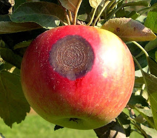
Bitter rot on Idared apple.

Same fruit as above, cut to show the diagnostic cone-shaped progression of the bitter rot fungus into the fruit.
As an indicator of the development of the sooty blotch and flyspeck (SBFS) fungal complex, we record accumulated wetting hours from rainfall or dew. As of Aug 1, accumulated wetting hours (ACW) since May 4 are: at 909 ft elevation, 524 hr (with the 250-hr threshold reached Jun 7; sooty blotch first observed Jul 7); at 932 ft (the AREC NEWA station), 363 hr, threshold reached Jul 5; and at the 983 ft elevation, 302 hr ACW, threshold reached Jul 21.  The significance of the 250-hr threshold is that it predicts the presence of the fungi causing SBFS symptoms on unprotected fruit.

Since July 1, rainfall has been scattered, with a total of 3.66 in. for the NEWA station at Gadino Cellars  in Rappahannock County, VA. Augusta County  Barren Ridge, Fishersville rainfall total was less with 1.98 in. in July, but an additional 1.17 in. on Aug 1. July total rainfall was was generally lighter for Albemarle County ranging from 1.89 in. at Batesville, to 0.57 in. at Carter Mt. 

As of Aug 1, accumulation of wetting hours since Apr 30 at Tyro, 941 ft elevation was 512 hr, with the 250-hr threshold reached on June 12. The NEWA station at Gadino Cellars (elev. 665 ft, in Washington, VA) passed the threshold of 250 ACW June 16, and has now recorded 394 wetting hours since May 1. The NEWA station at Fishersville also passed the 250-hr threshold June 16 and now has 390 ACW. Three Albemarle County NEWA stations have also passed the 250-hr threshold, listed with ACW as of Aug 1 and date the was threshold reachedBatesville (367 ACW, July 2); Crozet (309 ACW, July 5); Carter Mt. (292 ACW, July 6).

Friday, July 21, 2017

Summer disease update, July 21.


Overall, conditions remain generally dry, and some good soaking rains would be welcomed for fruit and other crops in the Winchester area. This week we had one extended wetting event at our AREC in Winchester: Jul 17-18, wet 11 hr at 71°  but with only 0.1 in. of rain. As an indicator of earlier wetting conditions, we are now seeing sooty blotch, Brooks fruit spot, and bitter rot on unprotected apple fruits at our AREC . A bright spot in the situation is for ripening peaches, where reduced volume of rainfall should increase sweetness and, hopefully, reduce brown rot pressure.

For purposes of predicting the development of the sooty blotch and flyspeck (SBFS) fungal complex, we record accumulated wetting hours from rainfall or dew, starting from May 4, 10 days after petal fall. While we have been lacking volume of rainfall, we continue to accumulate wetting hours at lower elevations in the orchard. As of Friday morning July 21, accumulated wetting hours (ACW) toward the 250 wetting hour threshold for specific treatment against the SBFS fungal complex were: at 909 ft elevation, 439 hr (with the 250-hr threshold reached Jun 7; sooty blotch first observed Jul 7); at 932 ft (the AREC NEWA station), 309 hr, threshold reached Jul 5; and at the 983 ft elevation, 250 hr ACW.  The significance of the 250-hr threshold is that it predicts that the fungi causing SBFS symptoms are now present on unprotected fruit, and that is confirmed by symptoms at our AREC.

For Nelson County in central Virginia, the petal fall date was Apr 20, and accumulation of wetting hours from Apr 30 is recorded by weather stations at different elevations at Tyro. As of July 7, a sensor placed at 1465 ft. elevation had accumulated only 98 wetting hours from Apr 30, while the one placed at 941 ft elevation had accumulated 448 hr, with the 250-hr threshold reached on June 12).

The NEWA station at Gadino Cellars (elev. 665 ft, in Washington, VA) passed the threshold of 250 ACW June 16, and has now recorded 360 wetting hours since May 1. A NEWA station at Fishersville also passed the 250-hr threshold June 16 and now has 334 ACW. Three Albemarle County NEWA stations have also passed the 250-hr threshold, listed with ACW as of July 21 and date the was threshold reached Batesville (313 ACW, July 2); Crozet (277 ACW, July 5); Carter Mt. (259 ACW, July 6).

Saturday, July 8, 2017

Summer disease update July 8


After a relatively dry month of June in the Winchester area, summer disease activity has increased this past weekThere was an extended wetting event at our AREC that will contribute to summer disease pressureJul 4-7, wet 38 hr at 70° with 0.88 in. of rain. Some areas east of Winchester and in central Virginia reported more than 2 inches of rain. We are now seeing early sooty blotch symptoms and bitter rot at our AREC in Winchester.

For purposes of predicting the development of the sooty blotch and flyspeck (SBFS) fungal complex, we record accumulated wetting hours from rainfall or dew, starting 10 days after petal fall. This year our petal fall date at Winchester was Apr 24, so the start of wetting hour accumulation was from May 4. As of Friday morning July 7, accumulated wetting hours (ACW) toward the 250 wetting hour threshold for specific treatment against the SBFS fungal complex were: at 909 ft elevation, 380 hr (with the 250-hr threshold reached Jun 7; sooty blotch observed Jul 7); at 932 ft (the AREC NEWA station), 283 hr; and at the 983 ft elevation, 230 hr ACW.  Reaching of the 250 hr threshold predicts that the fungi causing SBFS symptoms are now present on unprotected fruit and that is confirmed by symptoms at our AREC.

For Nelson County in central Virginia, the petal fall date was Apr 20, and accumulation of wetting hours from Apr 30 is recorded by weather stations at different elevations at Tyro. As of July 7, a sensor placed at 1465 ft. elevation had accumulated only 96 wetting hours from Apr 30, while the one placed at 941 ft elevation had accumulated 410 hr, with the 250-hr threshold reached on June 12).

The NEWA station at Gadino Cellars (elev. 665 ft, in Washington, VA) passed the threshold of 250 ACW June 16, and has now recorded 337 wetting hours since May 1. A NEWA station at Fishersville also passed the 250-hr threshold June 16 and now has 319 ACW. Three Albemarle County NEWA stations have also passed the 250-hr threshold, listed with CWH as of July 7 and date the was threshold reached : Batesville (273 CWH, July 2); Crozet (272 CWH, July 5); Carter Mt. (252 CWH, July 6).

Glomerella leaf spot activity has been reported from central Virginia.

Friday, June 23, 2017

Extended wetting event June 16-17, and accumulated wetting hours


The past 10 days there was one extended wetting at our AREC event that could contribute to summer disease pressures in the coming weeks: Jun 16-17, wet 20 hr at 70° with 0.62 in. rain. 

For purposes of predicting the development of the sooty blotch and flyspeck (SBFS) fungal complex, we record accumulated wetting hours from rainfall or dew, starting 10 days after petal fall. This year our petal fall date at Winchester was Apr 24, so the start of wetting hour accumulation was from May 4. As of Friday morning June 23, accumulated wetting hours (ACW) toward the 250 wetting hour threshold for specific treatment against the SBFS fungal complex were: at 909 ft elevation, 316 hr (with the 250-hr threshold reached Jun 7); at 932 ft (the AREC NEWA station), 226 hr; and at the 983 ft elevation, 183 hr ACW.  Reaching of the 250 hr threshold predicts that the fungi causing SBFS symptoms are now present on unprotected fruit and that symptoms on such fruit should appear in about 2 weeks.

For Nelson County in central Virginia, the petal fall date was Apr 20, and accumulation of wetting hours from Apr 30 is recorded by weather stations at different elevations at Tyro. Wetting hour accumulation in central Virginia was slow last week. As of June 23, a sensor placed at 1465 ft. elevation had accumulated only 90 wetting hours from Apr 30, while the one placed at 941 ft elevation had accumulated 341 hr- just over the 250-hr threshold).

The NEWA station at Gadino Cellars (elev. 665 ft, in Washington, VA) passed the threshold of 250 ACW last week, and has now recorded 286 wetting hours since May 1. A NEWA station at Fishersville has also passed the 250-hr threshold with 294 ACW.

Tuesday, June 13, 2017

Accumulated wetting thresholds reached at lower elevations


The past week there have been a minimal amounts of rainfall in the Winchester and central Virginia areas, but there continues to be wetting hour accumulation at the lower elevations. 

For purposes of predicting the development of the sooty blotch and flyspeck (SBFS) fungal complex, we record accumulated wetting hours from rainfall or dew, starting 10 days after petal fall. This year our petal fall date at Winchester was Apr 24, so the start of wetting hour accumulation was from May 4. As of Monday morning June 12, accumulated wetting hours (ACW) toward the 250 wetting hour threshold for specific treatment against the SBFS fungal complex were: at 909 ft elevation, 271 hr (21 CWH over the 250-hr threshold); at 932 ft (the AREC NEWA station), 184 hr; and at the 983 ft elevation, 153 hr ACW. In the past week most of the wetting hour accumulation was from dew and occurred more at lower elevations in the orchard. Note that at the lowest elevation, the ACW of 271 hr reached the threshold level of 250 ACW on June 7. This predicts that the fungi causing SBFS symptoms are now present on unprotected fruit and that symptoms on such fruit should appear in about 2-3 weeks.

For Nelson County in central Virginia, the petal fall date was Apr 20, and accumulation of wetting hours from Apr 30 is recorded by three weather stations at different elevations at Tyro. Wetting hour accumulation in central Virginia was slow last week. As of June 5, a sensor placed at 1465 ft. elevation had accumulated only 76 wetting hours from Apr 30, while the one at 1165 ft. had accumulated 164 wetting hours, and the one placed at 941 ft elevation had accumulated 254 hr- just over the 250-hr threshold).

The NEWA station at Gadino Cellars (elev. 665 ft, in Washington, VA) is approaching the threshold level of 250 ACW this week, having recorded 246 wetting hours since May 1. A NEWA station at Fishersville is also approaching the 250-hr threshold with 238 ACW.

Tuesday, June 6, 2017

Early summer disease activity


For purposes of predicting the development of the sooty blotch and flyspeck (SBFS) fungal complex, we record accumulated wetting hours from rainfall or dew, starting 10 days after petal fall. This year our petal fall date at Winchester was Apr 24, so the start of wetting hour accumulation was from May 4. As of Monday morning June 5, accumulated wetting hours (ACW) toward the 250 wetting hour threshold for specific treatment against the SBFS fungal complex were: at 909 ft elevation, 241 hr; at 932 ft (the AREC NEWA station), 180 hr; and at the 983 ft elevation, 143 hr ACW. In the past week most of the wetting hour accumulation was from dew and occurred more at lower elevations in the orchard. Note that at the lowest elevation, the ACW of 241 hr will probably reach the threshold level of 250 ACW this week.

For Nelson County in central Virginia the petal fall date was Apr 20, and accumulation of wetting hours from Apr 30 is recorded by three weather stations at different elevations at Tyro. Wetting hour accumulation in central Virginia was slow last week. As of June 5, a sensor placed at 1465 ft. elevation had accumulated only 76 wetting hours from Apr 30, while the one at 1165 ft. had accumulated 151 wetting hours, and the one placed at 941 ft elevation had accumulated 199 hr.

The NEWA station at Gadino Cellars (elev. 665 ft, in Washington, VA) will probably also reach the threshold level of 250 ACW this week, having recorded 238 wetting hours since May 1.

We have had several reports of other early summer disease activity: bitter rot mummies forming on fire-blighted shoots and early Glomerella leaf spot symptoms in central Virginia and Alternaria leaf blotch on Red Delicious in Rockingham County.

Wednesday, May 31, 2017

Disease Update; Accumulated wetting hours and extended wetting events


Early this week we recorded another extended wetting event at our AREC: May 28-29, wet 12 hr at 63° with 0.04 in. rain. 

For purposes of predicting the development of the sooty blotch and flyspeck (SBFS) fungal complex, we record accumulated wetting hours from rainfall or dew, starting 10 days after petal fall. This year we chose Apr 24 as our petal fall date for Winchester, so the start of wetting hour accumulation was from May 4. As of Monday morning May 29, accumulated wetting hours (ACW) toward the 250 wetting hour threshold for specific treatment against the SBFS fungal complex were: at 909 ft elevation, 204 hr; at 932 ft (the AREC NEWA station), 167 hr; and at the 983 ft elevation, 139 hr ACW. In the past week some wetting hour accumulation occurred from both rainfall and dew. 

For central Virginia, we have selected Apr 20 as the petal fall date, and accumulation of wetting hours from Apr 30 is recorded by three weather stations at different elevations at Tyro. As of May 29, a sensor placed at 1465 ft. elevation had accumulated only 75 wetting hours from Apr 30, while the one at 1165 ft. had accumulated 147 wetting hours, and the one placed at 941 ft elevation had accumulated 187 hr.

The NEWA station at Gadino Cellars (elev. 665 ft, in Washington, VA) has recorded 206 wetting hours since May 1.

Friday, May 26, 2017

More of the same...


We have had several more extended wetting periods this week, favorable for both scab and cedar-apple rust and early summer disease development: May 23-24, wet 11 hr at 54° with 0.48 in. rain; May 24-25, wet 15 hr at 55° with 0.96 in. rain; . May 25-26 wet more than 9 hr at 56° with 0.56 in. rain.

Apple scab pressure has been significant this year, with five infection periods Mar 27- Apr 7 and enough rainfall to cause weathering of protectant fungicides during that time. Lesions from those infection periods were present to cause secondary infection Apr 22-26 and during later infection periods May 4-6, May 11-13, May 21-22, and the recent ones this week. Combinations of fungicides with protective action and after-infection activity for scab are suggested for control during repeated conditions with 1-2 inches of rainfall followed by extended wetting that favors additional infection.

Cedar-apple rust: Rusts have been active for 8 weeks and cedar rust galls were still active May 25-26. Cedar-apple rust lesions and some quince rust lesions are present from the Apr 24-26 and May 4-6 infection periods and more foliar infection is appearing from the more recent ones. Considering continued cedar gall activity and infection conditions this week, it would still be prudent to include an SI fungicide for after-infection rust control in the next application if there is any doubt about lack of protective residue. The recent wetting will add to the accumulated wetting hour totals for development of sooty blotch and flyspeck which will be updated early next week.

Stone fruits: Continue to protect peaches against peach scab which is also favored by the above conditions described for apple scab. Also, protect ripening cherries against brown rot and Alternaria rot which are favored by these wet conditions during the pre-ripening period.

Tuesday, May 23, 2017

Disease update May 23.


We have some continuing apple scab activity, with a secondary infection period across the region from Winchester southward to Roanoke and east of the Blue Ridge May 21-22. Length of wetting varied from 7-16 hr at temperatures of 58-70° and mostly less than an inch of rain. More extended wetting is forecast for May 23-24. Later this week and early next week we expect secondary scab lesions to appear from the heavy secondary infection period May 11-13 

For purposes of predicting the development of the sooty blotch and flyspeck (SBFS) fungal complex, we record accumulated wetting hours from rainfall or dew, starting 10 days after petal fall. This year we chose Apr 24 as our petal fall date for Winchester, so the start of wetting hour accumulation was from May 4. As of May 22, accumulated wetting hours (ACW) toward the 250 wetting hour threshold for specific treatment against the SBFS fungal complex were: at 909 ft elevation, 127 hr; at 932 ft (the AREC NEWA station), 109 hr; and at the 983 ft elevation, 84 hr ACW. In the past week some wetting hour accumulation occurred from both rainfall and dew. 

For central Virginia, we have selected Apr 20 as the petal fall date, and accumulation of wetting hours from Apr 30 is recorded by three weather stations at different elevations at Tyro. As of May 22, a sensor placed at 1465 ft. elevation had accumulated only 35 wetting hours from Apr 30, while the one at 1165 ft. had accumulated 83 wetting hours, and the one placed at 941 ft elevation had accumulated 115 hr.

Apple powdery mildew remains active on susceptible new growth. Mildew is a dry weather disease, and conidiospores were available for infection at Winchester as early as Mar 27. Since then we have had 23 days suitable for mildew infection through May 22. 

East of the Blue Ridge we have seen several examples of fire blight blossom infection.

Monday, May 15, 2017

Apple scab infection period May 11-13. Early summer disease developments.


At Winchester we recorded a heavy secondary apple scab infection period May 11-13, with 46 hr wetting with a mean temperature of 49° and 1.82 inches of rain. This volume of rainfall could have eliminated much of the protective fungicide residue during the extended wetting to allow some scab and rust infection. 

Areas in the Valley, southward to Roanoke, and areas east of the Blue Ridge from Fauquier County south to Lynchburg and Danville also saw extended wetting periods ranging from 32-48 hr, all at temperatures in the low to mid-50s. The more southern areas had split wetting periods or two separate ones starting May 9. These conditions also favored peach scab infection.

Rusts have been active in the Winchester area for six weeks, and some cedar rust galls are still active. Cedar-apple rust lesions (shown below) and some quince rust lesions are now appearing from the Apr 24-26 infection period; others from the extended wetting May 4-6 are expected this week.


May 10, 2017. Early appearance of cedar-apple rust lesions and scab (upper left) from the infection period Apr 24-26.
Apple powdery mildew conidia were available for infection at Winchester as early as Mar 27, and there have been 18 “dry weather“ mildew days suitable for mildew infection from Mar 27 to May 14. The image below illustrates the appearance of a primary mildew shoot and secondary infection on an adjacent shoot. 

Adjacent Golden Delicious shoots infected with primary infection (right) and secondary infection (left). Primary infection emerges with shoot growth from an infected overwintering bud. Secondary infection is usually heavier near a primary inoculum source.

For purposes of predicting the development of the sooty blotch and flyspeck (SBFS) fungal complex, we record accumulated wetting hours from rainfall or dew, starting 10 days after petal fall. This year we have chosen Apr 24 as our petal fall date for Winchester, so the start of wetting hour accumulation is from May 4. As of May 14, accumulated wetting hours (ACW) toward the 250 wetting hour threshold for specific treatment against the SBFS fungal complex were: at 909 ft elevation, 98 hr; at 932 ft (the AREC NEWA station), 83 hr; and at the 983 ft elevation, 73 hr ACW. One of the purposes of following three weather stations is to compare wetting hour accumulation at different elevations; however, because many of the early wetting hours this year were a result of rainfall rather than dew, the early accumulation trend this year is a bit different than in some previous years. 


For central Virginia, we have selected Apr 20 as the petal fall date for accumulation of wetting hours by weather stations at Tyro. As of May 14, a sensor placed at 1465 ft. elevation had accumulated only 31 wetting hours from Apr 30, while the one at 1165 ft. had accumulated 72 wetting hours, and the one placed at 941 ft elevation had accumulated 94 hr.

Monday, May 8, 2017

Widespread scab and rust infection period May 4-6


WIDESPREAD SCAB and RUST INFECTION PERIOD: A widespread secondary scab infection period occurred May 4-6 from Danville, Roanoke and Lynchburg areas northward through Winchester. In Winchester we recorded 22 hr wetting with a mean temperature of
55° and 2.6 inches of rainfall. This volume of rainfall could have eliminated much of the fungicide residue early enough during the extended wetting to allow some scab and rust infection.

A survey of eleven NEWA weather stations in Virginia showed volumes of rainfall ranging around 2 to 3 inches at most recording stations, but Danville had 1.2 in. of rain and 18 hr wetting while some Albemarle County stations had more than 3 inches, and Rappahannock County had as much as 5.4 inches and 44 hr wetting. Temperatures were warm enough at all locations to allow cedar-apple rust infection wherever inoculum is still present. There are still active cedar rust galls at Winchester.

Also, these conditions May 4-6 favored peach scab infection.

FIREBLIGHT UPDATE: Fire blight conditions developed much as predicted in the May 1 post, with possible infection conditions May 1, only wetting lacking May 2, then declining risk with cooler temperatures that are predicted to continue through May 13. The remaining susceptible bloom in the Winchester area is mostly on recently planted trees. 

Monday, May 1, 2017

Fire blight outlook May 1-5.


NOTE: This year for fire blight risk assessment, we are comparing graphics from Maryblyt 7 and from the Cougarblight model as shown on our NEWA site. We are using the same weather data from our NEWA station to make these comparisons in both predictive programs.

CAUTION: The observations, conditions, and recommendations reported for Winchester, VA are provided as a guide to fire blight risk assessment only for the immediate area of the Virginia Tech AREC located six miles southwest of Winchester. Use of the information reported here for making orchard management decisions outside of that area is not our intent. Fruit producers outside of that area are encouraged to consult their state extension specialists for information similar to that provided here.
Maryblyt graphic May 1, 2017. Click to enlarge.
FIRE BLIGHT: Above is a cropped graphic from the Maryblyt 7 program, using Apr 5 as the date for first bloom open on Idared cultivar. Some early cultivars still have scattered susceptible bloom, while later cultivars are beyond petal fall but still with susceptible bloom in the Winchester and central Virginia areas. Some recently planted trees still have much susceptible bloom. The temperature and rainfall data are current through Sunday evening, Apr 30. Predicted weather conditions are shown for May 1-5. The components of fire blight risk are indicated in the columns labeled B (blossoms open), H (degree hours for epiphytic bacterial populations), W (wetting by rain or dew), and T (average daily temperature 60 F or above). For infection to be predicted, wetting must occur after the EIP (epiphytic infection potential) reaches 100 or higher. Based on recorded temperatures and wetting, the risk column shows high risk and possible infection with any wetting Apr 11-12, 15-18, 21 and, and if bloom persists, Apr 27-May 2. Infection was indicated for Apr 12, 15-17 21 and Apr 28-30. Predicted warming temperatures have again increased risk wherever susceptible bloom remains through May 2, then declines with cooler temperatures through May 5. Note that risk can change quickly with warmer than predicted temperatures and wetting. Continue to protect late bloom and open bloom on recently planted trees as needed.

The BBS column is tracking predicted symptom development for the first infection Apr 12 and symptoms are predicted to appear Apr 27. Later infections are tracked with letters b-e, and symptoms for those are predicted to appear Apr 28-May 2. The CBS column indicates progression toward the appearance of canker margin symptoms due to extension of overwintering cankers from last year, which were predicted to Apr 22. Canker advancement cannot be prevented by chemical treatment at this time and the presence of symptoms will signal build-up of inoculum which could become a factor in the event of a trauma blight/shoot blight situation due to hail injury, etc. To offset the potential for shoot tip infection in an active fire blight year such as this one, apply the plant growth regulator, prohexadione-calcium (Apogee, Kudos), at late bloom. Shoot blight suppression results from hardening off of vegetative shoot growth starting about 10 days after the initial application.

Below is the graphic from the Cougarblight model as shown on our NEWA site. Note that we selected orchard blight history option as “Fire blight occurred in your neighborhood last year” and first blossom open date as 4/5/2017. (This date must be re-set each time this site is accessed). Cougarblight shows color-coded risk as “extreme” Apr 28-May 3.
Cougarblight graphic May 1, 2017. Click to enlarge.

Friday, April 28, 2017

Fire blight outlook April 28-May 3.


NOTE: This year for fire blight risk assessment, we are comparing graphics from Maryblyt 7 and from the Cougarblight model as shown on our NEWA site. We are using the same weather data from our NEWA station to make these comparisons in both predictive programs.

CAUTION: The observations, conditions, and recommendations reported for Winchester, VA are provided as a guide to fire blight risk assessment only for the immediate area of the Virginia Tech AREC located six miles southwest of Winchester. Use of the information reported here for making orchard management decisions outside of that area is not our intent. Fruit producers outside of that area are encouraged to consult their state extension specialists for information similar to that provided here.
Maryblyt graphic April 28, 2017
FIRE BLIGHT: Above is a cropped graphic from the Maryblyt 7 program, using Apr 5 as the date for first bloom open on Idared cultivar. Early-blooming cultivars still have scattered susceptible bloom, and later cultivars are at petal fall but with much susceptible bloom in the Winchester and central Virginia areas. Some recently planted trees still have much susceptible bloom. The temperature and rainfall data are current through Thursday evening, Apr 27. Predicted weather conditions are shown for April 28-May 3. The components of fire blight risk are indicated in the columns labeled B (blossoms open), H (degree hours for epiphytic bacterial populations), W (wetting by rain or dew), and T (average daily temperature 60 F or above). For infection to be predicted, wetting must occur after the EIP (epiphytic infection potential) reaches 100 or higher. Based on recorded temperatures and wetting, the risk column shows high risk and possible infection with any wetting Apr 11-12, 15-18, 21 and, and if bloom persists, Apr 27-May 3. Infection was indicated for Apr 12, 15-17 and 21. Predicted warming temperatures have again increase risk wherever susceptible bloom remains Apr 26-May 1. Note that risk can change quickly with warmer than predicted temperatures and wetting. In situations where all other requirements for infection have been met except wetting (as for May 1-3, wetting from any spray application (fungicide, insecticide, or thinning spray) can provide the wetting trigger for infection to occur. In high-risk situations, a protective streptomycin application is recommended ahead of predicted infection. Continue to protect late bloom and open bloom on recently planted trees as needed.

The BBS column is tracking predicted symptom development for the first infection Apr 12 and symptoms are predicted to appear Apr 27. Later infections are tracked with letters b-e, and symptoms for those are predicted to appear Apr 28-May 2. The CBS column indicates progression toward the appearance of canker margin symptoms due to extension of overwintering cankers from last year, which were predicted to Apr 22. Canker advancement cannot be prevented by chemical treatment at this time and the presence of symptoms will signal build-up of inoculum which could become a factor in the event of a trauma blight/shoot blight situation due to hail injury, etc. To offset the potential for shoot tip infection in an active fire blight year such as this one, apply the plant growth regulator, prohexadione-calcium (Apogee, Kudos), at late bloom. Shoot blight suppression results from hardening off of vegetative shoot growth starting about 10 days after the initial application. The fire blight outlook will be updated Monday, May 1.

Below is the graphic from the Cougarblight model as shown on our NEWA site. Note that we selected orchard blight history option as “Fire blight occurred in your neighborhood last year” and first blossom open date as 4/5/2017. (This date must be re-set each time this site is accessed). Cougarblight shows color-coded risk as “high” for Apr 27 and “extreme” Apr 28-May 2. 
Cougarblight graphic April 28, 2017.

Wednesday, April 26, 2017

Heavy scab and rust infection period and fire blight outlook Apr 26-May 1.


NOTE: This year for fire blight risk assessment, we are comparing graphics from Maryblyt 7 and from the Cougarblight model as shown on our NEWA site. We are using the same weather data from our NEWA station to make these comparisons in both predictive programs.

CAUTION: The observations, conditions, and recommendations reported for Winchester, VA are provided as a guide to fire blight risk assessment only for the immediate area of the Virginia Tech AREC located six miles southwest of Winchester. Use of the information reported here for making orchard management decisions outside of that area is not our intent. Fruit producers outside of that area are encouraged to consult their state extension specialists for information similar to that provided here.

SCAB and RUSTS:  We have just seen extended wetting of more than 46 hours. Because apple scab lesions resulting from infection periods during the period March 26 to Apr 7 may have been present, consider this to be a heavy secondary infection period. Also, because of the high susceptibility of developing fruits to quince rust, it is suggested that fungicides with strong after-infection activity against rusts and scab be included in the next fungicide application.
Maryblyt graphic for Winchester, Apr 26, 2017. Click to enlarge.
FIRE BLIGHT: Above is a cropped graphic from the Maryblyt 7 program, using Apr 5 as the date for first bloom open on Idared cultivar. Early-blooming cultivars still have scattered susceptible bloom, and later cultivars are at petal fall but with much susceptible bloom in the Winchester and central Virginia areas. Some recently planted trees still have much susceptible bloom. The temperature and rainfall data are current through Tuesday evening, Apr 25. Predicted weather conditions are shown for April 26-May 1. The components of fire blight risk are indicated in the columns labeled B (blossoms open), H (degree hours for epiphytic bacterial populations), W (wetting by rain or dew), and T (average daily temperature 60 F or above). For infection to be predicted, wetting must occur after the EIP (epiphytic infection potential) reaches 100 or higher. Based on recorded temperatures and wetting, the risk column shows high risk and possible infection with any wetting Apr 11-12, 15-18, and 21, and if bloom persists, Apr 27-May 1. Infection was indicated for Apr 12, 15-17 and 21. Predicted warming temperatures will again increase risk wherever susceptible bloom remains Apr 26-May 1. Note that risk can change quickly with warmer than predicted temperatures and wetting. In situations where all other requirements for infection have been met except wetting (as for Apr 27-May 1), wetting from any spray application (fungicide, insecticide, or thinning spray) can provide the wetting trigger for infection to occur. In high-risk situations, a protective streptomycin application is recommended ahead of predicted infection. Continue to protect late bloom and open bloom on recently planted trees as needed.

The BBS column is tracking predicted symptom development for the first infection Apr 12 and symptoms are predicted to appear Apr 27. Later infections are tracked with letters b-d, and symptoms for those are predicted to appear Apr 28-30. The CBS column indicates progression toward the appearance of canker margin symptoms due to extension of overwintering cankers from last year, which would be predicted to occur after that value reached 100 Apr 22. Canker advancement cannot be prevented by chemical treatment at this time and the presence of symptoms will signal build-up of inoculum which could become a factor in the event of a trauma blight/shoot blight situation due to hail injury, etc. To offset the potential for shoot tip infection in an active fire blight year such as this one, apply the plant growth regulator, prohexadione-calcium (Apogee, Kudos), at late bloom. Shoot blight suppression results from hardening off of vegetative shoot growth starting about 10 days after the initial application. The fire blight outlook will be updated Friday, Apr 28.

Below is the graphic from the Cougarblight model as shown on our NEWA site. Note that we selected orchard blight history option as “Fire blight occurred in your neighborhood last year” and first blossom open date as 4/5/2017. (This date must be re-set each time this site is accessed). Cougarblight shows color-coded risk as “high” for Apr 27 and “extreme” for Apr 28-30. 
Cougarblight graphic for Winchester, Apr 26, 2017. Click to enlarge.

Monday, April 24, 2017

Fire blight and scab outlook April 24-28.


NOTE: This year for fire blight risk assessment, we are comparing graphics from Maryblyt 7 and from the Cougarblight model as shown on our NEWA site. We are using the same weather data from our NEWA station to make these comparisons in both predictive programs.

CAUTION: The observations, conditions, and recommendations reported for Winchester, VA are provided as a guide to fire blight risk assessment only for the immediate area of the Virginia Tech AREC located six miles southwest of Winchester. Use of the information reported here for making orchard management decisions outside of that area is not our intent. Fruit producers outside of that area are encouraged to consult their state extension specialists for information similar to that provided here.

APPLE SCAB lesions resulting from infection periods during the period March 26 to Apr 7 may be present in poorly protected orchards, and extended wetting could result in heavy secondary infection this week, Apr 24-26.

Maryblyt graphic for Winchester, Apr 24, 2017. Click to enlarge.
FIRE BLIGHT: Above is a cropped graphic from the Maryblyt 7 program, using Apr 5 as the date for first bloom open on Idared cultivar. Many trees still have some susceptible bloom in the Winchester area. The temperature and rainfall data are current through Sunday evening, Apr 23. Predicted weather conditions are shown for April 24-28. The components of fire blight risk are indicated in the columns labeled B (blossoms open), H (degree hours for epiphytic bacterial populations), W (wetting by rain or dew), and T (average daily temperature 60 F or above). For infection to be predicted, wetting must occur after the EIP (epiphytic infection potential) reaches 100 or higher. Based on recorded temperatures and wetting, the risk column shows high risk and possible infection with any wetting Apr 11-12, 15-18, and 21, and if bloom persists, Apr 27-28. Infection was indicated for Apr 12, and 15-17 and is predicted with wetting Apr 21. Note that risk can change quickly with unpredicted warmer temperatures and wetting. In high-risk situations, a protective streptomycin application is recommended ahead of predicted infection. Predicted cooler temperatures should reduce risk Apr 24-25, but will probably cause late bloom to persist, setting up higher risk of infection of late bloom with warmer temperatures Apr 27-28. Continue to protect late bloom and open bloom on young trees as needed.

The BBS column is tracking predicted symptom development for the first infection Apr 12 and symptoms are predicted to appear Apr 27. The CBS column indicates progression toward the appearance of canker margin symptoms due to extension of overwintering cankers from last year, which would be predicted to occur after that value reached 100 Apr 22. Canker advancement cannot be prevented by chemical treatment at this time and the presence of symptoms will signal build-up of inoculum which could become a factor in the event of a trauma blight/shoot blight situation due to hail injury, etc. To offset the potential for shoot tip infection in an active fire blight year such as this one, apply the plant growth regulator, prohexadione-calcium (Apogee, Kudos), at late bloom. Shoot blight suppression results from hardening off of vegetative shoot growth starting about 10 days after the initial application. The fire blight outlook will be updated Wednesday, Apr 26.

Below is the graphic from the Cougarblight model as shown on our NEWA site. Note that we selected orchard blight history option as “Fire blight occurred in your neighborhood last year” and first blossom open date as 4/5/2017. (This date must be re-set each time this site is accessed). Cougarblight shows color-coded risk as “extreme” Apr 21, and “high” Apr 22-23 then declining Apr 24-26, but returning to high and extreme Apr 27-28. 

Cougarblight graphic for Winchester, Apr 24, 2017. Click to enlarge.

Friday, April 21, 2017

Fire blight risk outlook for Winchester April 21-26.


NOTE: This year for fire blight risk assessment, we are comparing graphics from Maryblyt 7 and from the Cougarblight model as shown on our NEWA site. We are using the same weather data from our NEWA station to make these comparisons in both predictive programs.

CAUTION: The observations, conditions, and recommendations reported for Winchester, VA are provided as a guide to fire blight risk assessment only for the immediate area of the Virginia Tech AREC located six miles southwest of Winchester. Use of the information reported here for making orchard management decisions outside of that area is not our intent. Fruit producers outside of that area are encouraged to consult their state extension specialists for information similar to that provided here.
Maryblyt graphic for Winchester, Apr 21, 2017. Click to enlarge.
FIRE BLIGHT: Above is a cropped graphic from the Maryblyt 7 program, using Apr 5 as the date for first bloom open on Idared cultivar. Early-blooming cultivars still have some susceptible bloom, and later cultivars are near full bloom in the Winchester area. The temperature and rainfall data are current through Thursday evening, April 20. Predicted weather conditions are shown for April 21-26. The components of fire blight risk are indicated in the columns labeled B (blossoms open), H (degree hours for epiphytic bacterial populations), W (wetting by rain or dew), and T (average daily temperature 60 F or above). For infection to be predicted, wetting must occur after the EIP (epiphytic infection potential) reaches 100 or higher. Based on recorded temperatures and wetting, the risk column shows high risk and possible infection with any wetting Apr 11-12, 15-18 21, 24-25 and with slightly warmer than indicated temperatures and wetting Apr 13-14 and 18-20. Infection was indicated for Apr 12, and 15-17 and is predicted with wetting Apr 21. Note that risk can change quickly with unpredicted warmer temperatures and wetting. In high-risk situations, a protective streptomycin application is recommended ahead of predicted infection. Predicted cooler temperatures should reduce risk Apr 22-24, but will probably cause late bloom to persist into next week, and predicted warmer temperatures Apr 26-30 (not shown) will probably again bring high risk to late bloom. Continue to protect late bloom and bloom on newly-planted trees as needed.

The BBS column is tracking predicted symptom development for the first infection Apr 12 and symptoms are predicted to appear Apr 26. (Symptoms from artificial inoculation Apr 9 already appeared at our AREC by Apr 18). The CBS column indicates progression toward the appearance of canker margin symptoms due to extension of overwintering cankers from last year, which would be predicted to occur when that value reaches 100 Apr 23. Canker advancement cannot be prevented by chemical treatment at this time and the presence of symptoms will signal build-up of inoculum which could become a factor in the event of a trauma blight/shoot blight situation due to hail injury, etc. To offset the potential risk of shoot tip infection in an active fire blight year such as this one, apply the plant growth regulator, prohexadione-calcium (Apogee, Kudos), at late bloom. Shoot blight suppression results from hardening off of vegetative shoot growth starting about 10 days after the initial application. The fire blight outlook will be updated Monday, Apr 24.

Below is the graphic from the Cougarblight model as shown on our NEWA site. Note that we selected orchard blight history option as “Fire blight occurred in your neighborhood last year” and first blossom open date as 4/5/2017. (This date must be re-set each time this site is accessed). Cougarblight shows color-coded risk assessment as “Cougarblight 4-Day DH” which was “extreme” Apr 17-19, and for today, Apr 21, and remains “high” Apr 22-23. 
Cougarblight graphic for Winchester, Apr 21, 2017. Click to enlarge.
Early blossom symptoms (center) Apr 18 from artificial inoculation Apr 9.