Friday, September 4, 2015

Bitter rot and summer disease pressures

This week we have had several reports of bitter rot showing up in Frederick County. For several weeks we have also seen it in our research plots at the AREC. Some may be associated with fire blight strikes, but more frequently they seem to be related to the presence of small fruit or flower mummies that served as the likely inoculum source.
Bitter rot on an Idared fruit with a small mummy, a probable inoculum source
Although it was quite dry throughout most of August, the bitter rot infection relates to warm wetting conditions as early as mid-May. From May 16 to Aug 11 we had 21 extended wetting periods at temperatures in the 70s and higher 60s, favorable to bitter rot activity. At our AREC we had only 0.14 in.of rain from Aug 11 to Sept 2, but some county locations have recorded considerably more rainfall than we have had at the AREC in the past month, so that adds to the potential problems. Although these conditions could also favor Glomerella leaf spot development, so far we have not had reports of this from Frederick County.

While we lacked wetting from rainfall, we continue to add accumulated wetting hours from dew. As of the Monday morning, Aug 31, total accumulated wetting hours (ACW) at the AREC were: at 909 ft elevation, 975 hr; at 952 ft elevation, 673 hr; and at the 983 ft elevation, 576 hr ACW. Since accumulation of wetting hours began May 14, this represents an increase of 5.5 wetting hours per foot of elevation drop from 983 to 909 ft. Continue to scout for sooty blotch, flyspeck, and fruit rots, especially at lower elevations in an orchard.

At Tyro, in Nelson County, total ACW as of Monday morning, Aug 31, were: at 941 ft elevation, 792 ACW; at 1165 ft, 415 ACW; and at 1465 ft, 473 ACW. An extended wetting event with substantial rainfall was recorded at Tyro Aug 18-19, 25 hr wet at 74-69° at the highest elevation.

Thursday, August 20, 2015

Summer disease update

Summer disease pressures remained steady last week.  The extended wetting event Aug 10-11, in progress at the time of the last post, amounted to 12 hr wet at 71° with 0.31 in. of rain.

As of the Monday morning, Aug 17, total accumulated wetting hours (ACW) at the AREC were: at 909 ft elevation, 864 hr; at 952 ft elevation, 611 hr; and at the 983 ft elevation, 539 hr ACW. Since accumulation of wetting hours began May 14, this represents an increase of 4.4 wetting hours per foot of elevation drop from 983 to 909 ft. The wetting hour accumulation differential is greater during times when wetting is from dew rather than during wetting from rain, because rain tends to wet both locations similarly. In the past 10 days we have recorded only 0.17 inch of rainfall, but recorded 87 hours of wetting from dew at the 909 ft elevation.  This is why we say to scout for sooty blotch, flyspeck, and fruit rots at lower elevations in an orchard.

At Tyro, in Nelson County, total ACW as of Monday morning, Aug 17, were: at 941 ft elevation, 718 ACW; at 1165 ft, 385 ACW; and at 1465 ft, 433 ACW. An extended wetting event with substantial rainfall was recorded at Tyro Aug 18-19, 16 hr wet and 1.2 in. of rain at 74-69°.

Tuesday, August 11, 2015

Increasing summer disease and brown rot pressures

Summer disease pressure increased in the past week, with two extended wetting events at our ARECAug 6-7, 16 hr wet at 68-65° with 0.11 in. of rain and Aug 9-10, 16 hr wet at 74-72° with 0.52 in. of rain. (Another extended wetting event is in progress at the time of this post).

As of the Monday morning, Aug 10, total accumulated wetting hours (ACW) at the AREC were: at 909 ft elevation, 796 hr; at 952 ft elevation, 567 hr; and at the 983 ft elevation, 518 hr ACW. Since accumulation of wetting hours began May 14, this represents an increase of 3.8 wetting hours per foot of elevation drop from 983 to 909 ft.

At Tyro, in Nelson County, total ACW as of Monday morning, Aug 10, were: at 941 ft elevation, 670 ACW; at 1165 ft, 368 ACW; and at 1465 ft, 409 ACW. 

The recent wetting events will again increase brown rot pressure on ripening peaches, as well as sooty blotch, flyspeck and rots on early ripening apples.

Wednesday, August 5, 2015

Summer disease update

Summer disease pressure was moderate in the past week, with one extended wetting event at our ARECJuly 28-29, 13 hr wet at 72-66° with 0.59 in. of rain. A thunderstorm during the early morning hours Aug 4 resulted in only 0.15 inch of rainfall and 4 hr wetting at our AREC, but the rainfall was likely much heavier in some Frederick County orchards.

As of the Monday morning, Aug 3, total accumulated wetting hours (ACW) at the AREC were: at 909 ft elevation, 739 hr; at 952 ft elevation, 522 hr; and at the 983 ft elevation, 476 hr ACW. Since accumulation of wetting hours began May 14, this represents an increase of 3.6 wetting hours per foot of elevation drop from 983 to 909 ft.

At Tyro, in Nelson County, total ACW as of Monday morning, Aug 3, were: at 941 ft elevation, 643 ACW; at 1165 ft, 352 ACW; and at 1465 ft, 393 ACW. 

Wednesday, July 29, 2015

Dry weather great for sweet ripening peaches

At our AREC we have recorded only 0.2 inch of rain and no extended wetting periods with rain in the past two weeks. Although it is starting to get pretty dry, this has been a welcome break for ripening peaches, producing sweeter fruit with less brown rot pressure.


Ripening Redhaven peach: Dry and bright sunny weather reduces brown rot pressure in the pre-harvest period
But the blemishes from scab lesions are an indicator of earlier season disease pressures. The incubation period for scab infection to appear can be as long as 6-7 weeks, sometimes leading to the question "Where did this come from?"

Earlier rot activity is showing up as bitter rot and other rots on Honeycrisp apples, and this brings reminders that anything that causes injury such as Japanese beetle, will increase the possibility of rot activity, especially as sugar levels increase.

As of the Monday morning, July 27, accumulated wetting hours (ACW) at the AREC are related to elevation: at 909 ft elevation, 687 hr; at 952 ft elevation, 486  hr; and at the 983 ft elevation 444 hr ACW. 

At Tyro, in Nelson County, total ACW as of Monday morning, July 27, were: at 941 ft elevation, 595 ACW; at 1165 ft, 311 ACW; and at 1465 ft, 354 (with the 250-hr threshold reached July 5). 

Thursday, July 16, 2015

Summer disease update

Summer disease pressure continued this past week with several extended wetting events at relatively warm temperatures and some locally heavy rainfall.

At our AREC we recorded three such extended wetting periods with rainfall: July 11, 9 hr wet at 71-66° with 0.28 in. of rain; July 13, 9 hr wet at 70° with 0.13 in. of rain (but as much as 4 inches with flooding locally in the Woodstock area of Shenandoah County)July 14, 11 hr wet at 70° with 0.34 in. of rain; . These frequent infection periods with rain deplete fungicide residue and continue to favor development of rots such bitter rot and white rot, as well as Alternaria and Glomerella leaf spots.

As of the Thursday morning, July 15, accumulated wetting hours (ACW) at the AREC are related to elevation: at 909 ft elevation, 588 hr; at 952 ft elevation, 467 hr; and at the 983 ft elevation 423 hr ACW. Since accumulation of wetting hours began May 14, this represents an increase of 2.2 wetting hours per foot of elevation drop from 983 to 909 ft!

At Tyro, in Nelson County, total ACW as of Thursday morning, July 15, were: at 941 ft elevation, 531 ACW; at 1165 ft, 299 ACW; and at 1465 ft, 345 (with the 250-hr threshold reached July 5). The 250-hr ACW threshold reached at all sensor elevations at Tyro early last week, and this probably true for all orchards in the central Virginia region.

The recent frequent wetting periods also favor development of brown rot on ripening peaches and other stone fruits.

Thursday, July 9, 2015

Continued summer disease pressure

Summer disease pressure continued this past week with a pattern of afternoon or evening showers followed by wetting through the night, all at relatively warm temperatures.

At our AREC we recorded five such extended wetting periods with rainfall: July 2, 10 hr wet at 64-73° with 0.16 in. of rain; July 3-4, 15 hr wet at 72-65° with 0.01 in. of rain; July 6, 9 hr wet at 70° with 0.14 in. of rain; July 6-7, 15 hr wet at 68° with 0.04 in. of rain; July 8-9, 15 hr wet at 68° with 0.05 in. of rain (but more than 1 inch in some local areas). These frequent infection periods all favored bitter rot and Glomerella leaf spot development, as well as other rots, and depleted much fungicide residue for sooty blotch and flyspeck control.

Accumulated wetting hours (ACW) at the AREC are related to elevation: at 909 ft elevation, 497 hr; at 952 ft elevation, 390 hr; and at the 983 ft elevation 347 hr ACW. 

At Tyro, in Nelson County, total ACW as of Monday, July 6 were: at 941 ft elevation, 449 ACW; at 1165 ft, 250 ACW; and at 1465 ft, 264 (with the 250-hr threshold reached July 5). Note that the threshold has now been reached at all sensor elevations at Tyro.

The recent frequent wetting periods also favor development of brown rot on ripening peaches.

Wednesday, July 1, 2015

Sooty blotch and flyspeck and other summer diseases

Early signs of sooty blotch and flyspeck were observed in lower elevation areas at our AREC Monday, June 29. At this elevation (909 ft) we had reached the 250-hour total accumulated wetting hour (ACW) action threshold June 10. At higher elevations, the dates that the 250-hr threshold was reached and ACW totals June 29 were: 952 ft elevation- June 13, 332 hr ACW; 983 ft elevation- June 21, 297 ACW. Note that the threshold had been reached by June 21 at all AREC locations ranging from 909 to 983 ft elevations.

At our AREC we had two more extended wetting periods that favored summer disease development: June 25-26, 14 hr wetting at 72-64° with 0.02 in. of rain; June 26-28, 32 hr wetting at 72-59° with 1.62 in. of rain. This latter volume of rainfall would have depleted most fungicide residue available for sooty blotch, flyspeck and rot control.

At Tyro in Nelson County, a sensor placed at at 941 ft elevation had already recorded the 250-hr ACW threshold by June 3 for a total of 384 hr by June 29. By June 29, the ones at higher elevations, 1465 ft and 1165 ft, had not yet reached the 250-hr threshold with only 216 and 212 wetting hours, respectively.

Thursday, June 25, 2015

Summer disease update

Several extended wetting periods at warm temperatures in the past 10 days strongly favored summer disease development: June 14-15, 22 hr wetting at 80-70° with 0.50 in. of rain; June 17-18, 19 hr wetting at 71° with 0.32 in. of rain; June 19-20, 15 hr wetting at 72°with 0.06 in. of rain; June 20-21, 12 hr wetting at 75° with 0.73 in. of rain. Note that all of these were above 70°, indicative of bitter rot and Glomerella leaf spot activity.

For the purpose of predicting the development of the sooty blotch and flyspeck (SBFS) fungal complex, we record accumulated wetting hours from rainfall or dew, starting 10 days after petal fall. We are tracking this as we have for the past 21 years using a hygrothermograph located at 952 ft. elevation. The start of wetting hour accumulation was from May 14. At this elevation we reached the 250 total accumulated wetting hour (ACW) action threshold June 13. As of the morning of June 24, ACW at the 952 elevation was 288. We also have electronic recorders at 909 ft and 983 ft elevations. At 909 ft ACW was more rapid with the 250-hr threshold reached June 10 and total ACW at 368 hr.  At 983 ft ACW was slower with the 250-hr threshold not reached until June 21; total ACW at 983 ft was 256 as of June 24 hr. 

For the central Virginia areas, represented by three weather stations at different elevations at Tyro in Nelson County, we started accumulation May 13.  A sensor placed at at 941 ft elevation had already greatly passed the 250-hr ACW threshold June 3 for a total of 335 hr by June 24. By June 24, the ones at higher elevations, 1465 ft and 1165 ft, had not yet reached the 250-hr threshold with only 175 and 183 wetting hours, respectively.

Tuesday, June 9, 2015

Extended wetting for scab and summer diseases

An extended wetting period last week, still in progress at the time of the last post June 5, ended at 14 hr wetting at 60°with 0.04 in. of rain

For purposes of predicting the development of the sooty blotch and flyspeck (SBFS) fungal complex, we record accumulated wetting hours from rainfall or dew, starting 10 days after petal fall. This year we have chosen May 4 as our petal fall start date for Winchester, and the start of wetting hour accumulation is from May 14. Last week we also had two nights with wetting from dew, totaling 18 hr. With a total of 96 wetting hours last week, our total accumulated wetting hours (ACW) came to 195 hours as of Monday, June 8. The threshold for specific treatment against the SBFS fungal complex is 250 wetting hours. 

A note to those farther south and east of the Blue Ridge: Your petal fall date may have been a week or more ahead of ours and I have updated the start date for accumulation of wetting hours by weather stations at Tyro, VA to May 3. One of the purposes of having three weather stations at this location is to compare wetting hour accumulation at different elevations. As of June 8, a sensor placed at at 941 ft elevation had already greatly passed the 250-hr ACW threshold for a total of 315 hr while the ones at higher elevations, 1465 ft and 1165 ft, had nearly identical ACW of 144 and 140 wetting hours, respectively. 

Alternaria leaf blotch, confirmed on Red Delicious leaves from Rockingham County May 21, continued to advance, as expected, with the extended wetting last week.

Friday, June 5, 2015

Fruit scab still a serious concern with extended wetting this week

After wetting periods of 16 hr May 30-31(0.13 in. rain) and 20 hr June 1-2 (1.2 in. rain), we have recorded almost continuous wetting 47 of 56 hours since 10 PM June 2. (It is still wet at the time of this post).

As fruits enlarge, they become more resistant to scab than the youngest leaves, so that at five weeks after petal fall, they require about double the length of wetting period at a given temperature than growing shoot tip leaves. But the several extended wetting periods the past week have easily surpassed the requirement for fruit infection. It is important to maintain protective residue now, to prevent fruit scab infection as well as early sooty blotch/flyspeck SBFS development.

Lower elevation orchards in central Virginia have passed the 250-hr accumulated wetting for SBFS. Also, we have confirmed Alternaria leaf blotch symptoms on Red Delicious leaves in Rockingham County.

Saturday, May 30, 2015

Scab and rust infection period; tracking sooty blotch and flyspeck development

We recorded another apple scab and cedar-apple rust infection period at our AREC May 26-27: 12 hours wetting with 0.4 inches of rain at 72-63°. Most cedar rust galls now seem to be depleted of inoculum.

For purposes of predicting the development of the sooty blotch and flyspeck (SBFS) fungal complex, we record accumulated wetting hours from rainfall or dew, starting 10 days after petal fall. This year we have chosen May 4 as our petal fall start date for Winchester, so the start of wetting hour accumulation is from May 14. As of Friday, May 30, we had accumulated 74 wetting hours toward the 250 wetting hour threshold for specific treatment against the SBFS fungal complex. 

A caution to those further south and east of the Blue Ridge: Your petal fall date may have been a week or more ahead of ours and we have arbitrarily selected Apr 27 as the start date for accumulation of wetting hours by weather stations at Tyro, VA. One of the purposes of having three weather stations at this location was to compare wetting hour accumulation at different elevations. As of May 29, a sensor placed at 1465 ft. elevation had accumulated 50 wetting hours from Apr 27, the one at 1165 ft. elevation had accumulated 90 wetting hours from May 11, while one placed at 941 ft elevation had already accumulated 204 hr!

Tuesday, May 19, 2015

Recent scab and rust infection periods; rust galls still active

We have seen two recent significant scab and rust infection periods: May 16-17 (22 hr wet at 74-71° with 0.77 in. rain) and May 18-19, 16 hr at 72-64° with 0.88 in. of rain.These are important for secondary scab infection where primary infection was not well-controlled earlier and, at temperatures in the 70s and higher 60s, also could signal some early Glomerella leaf spot and bitter rot activity. Cedar-apple rust galls are still actively producing spores.

We have had 22 dry weather powdery mildew infection days since mildew spores were first available Apr 6.

Yesterday we had reports of fire blight symptoms in the region, probably from infection that occurred May 5-7, which Maryblyt predicted to appear May 11-14.

Thursday, May 7, 2015

Continued fire blight risk; scab and rust infection May 5-7

CAUTION: The observations, conditions, and recommendations reported for Winchester, VA are provided as a guide to fire blight risk assessment only for the immediate area of the Virginia Tech AREC located six miles southwest of Winchester. Use of the information reported here for making orchard management decisions outside of that area is not our intent. Fruit producers outside of that area are encouraged to consult their state extension specialists for information similar to that provided here.


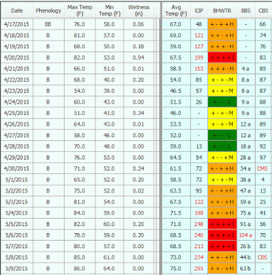
FIRE BLIGHT: Above is a cropped graphic from the Maryblyt 7 program. Many trees still have susceptible bloom. Here is the prediction for trees with first bloom open Apr 17-18, 2015. The temperature and rainfall data are current through Wednesday night, May 6. Predicted weather conditions are shown for May 7-11. The components of fire blight risk are indicated in the columns labeled B (blossoms open), H (degree hours for epiphytic bacterial populations), W (wetting by rain or dew), and T (average daily temperature 60 F or above). Based on recorded temperatures and wetting, the risk column shows that fire blight infection was possible Apr 20 and would have been possible with slightly warmer average temperatures for Apr 19 and 21. For infection to be predicted, wetting must occur after the EIP (epiphytic infection potential) reaches 100 or higher. 

Based on predicted temperatures, EIP will remain at an infective level through this  weekend, requiring only wetting to trigger infection conditions wherever susceptible bloom is present. Wetting from rain occurred at the AREC May 5 and 6. Other forms of wetting capable of triggering infection conditions include heavy dew, fog or routine spray applications-- anything that can splash the fire blight bacteria from the flower stigma into the nectaries in the base of the flower. Infection conditions remain possible with wetting wherever bloom is present May 7-11. This situation generally applies to other areas in the mid-Atlantic region well beyond Winchester. It is recommended that streptomycin be included with routine spray applications in high risk situations this week. Under the temperature conditions shown for this week, expect streptomycin to remain residually effective for only about 3 days.

The BBS column is tracking predicted appearance of blossom blight symptoms from infection that occurred Apr 20, and this is predicted for May 6. (Actually on May 4 we saw early symptoms from test inoculations Apr 20). Yesterday, May 6, blossom blight symptoms were observed in a Rappahannock County orchard, also likely from Apr 20 infection. The CBS column at the right in the graphic indicates progression toward the appearance of canker margin symptoms due to extension of overwintering cankers, with 100% of the degree-hour requirement May 1. Canker blight symptoms on new growth, due to extension of overwintering cankers are predicted for May 8. Canker advancement cannot be prevented by treatment and the presence of symptoms will signal build-up of inoculum which could become a factor in the event of a trauma blight situation due to hail injury, etc. The weather conditions used in the predictive part of this graphic come from the Weather Channel for Winchester, supplemented by site-specific data from SkyBit Inc. Be aware that risk can change quickly with unpredicted warmer temperatures and wetting.

Fungal diseases: Apple scab, quince rust, and cedar-apple rust infection periods occurred, with temperatures in the 60s, the nights of May 5 and 6. Blossoms are still susceptible to quince rust infection at petal fall.

Monday, May 4, 2015

Fire blight and fungal disease update

CAUTION: The observations, conditions, and recommendations reported for Winchester, VA are provided as a guide to fire blight risk assessment only for the immediate area of the Virginia Tech AREC located six miles southwest of Winchester. Use of the information reported here for making orchard management decisions outside of that area is not my intent. Fruit producers outside of that area are encouraged to consult their state extension specialists for information similar to that provided here.

(Click image for larger view)
FIRE BLIGHT: Above is a cropped graphic from the Maryblyt 7 program. Most cultivars still have much susceptible bloom. Here is the prediction for trees with first bloom open Apr 17-18, 2015. The temperature and rainfall data are current through Monday morning, May 4. Predicted weather conditions are shown for May 4-9. The components of fire blight risk are indicated in the columns labeled B (blossoms open), H (degree hours for epiphytic bacterial populations), W (wetting by rain or dew), and T (average daily temperature 60° F or above). Based on recorded temperatures and wetting, the risk column shows that fire blight infection was possible Apr 20 and would have been possible with slightly warmer average temperatures for Apr 19 and 21. For infection to be predicted, wetting must occur after the EIP (epiphytic infection potential) reaches 100 or higher. 

Based on predicted temperatures, EIP will remain at an infective level through this entire week, requiring only wetting to trigger infection conditions wherever susceptible bloom is present. Wetting from rain is shown as being predicted for May 5 and 6; other forms of wetting capable of triggering infection conditions include heavy dew, fog or routine spray applications-- any wetting event that will move the fire blight bacteria from the flower stigma into the nectaries in the base of the flower. It is recommended that streptomycin be included with any routine spray applications in high risk situations this week. Under the temperature conditions shown for this week, expect streptomycin to remain residually effective for only about 3 days.


The BBS column is tracking predicted appearance of blossom blight symptoms from infection that occurred Apr 20, and this is predicted for May 6. (Actually we are already seeing early symptoms from test inoculations Apr 20). The CBS column at the right in the graphic predicts the appearance of canker margin symptoms due to extension of overwintering cankers by Apr 30. Canker advancement cannot be prevented by treatment at this time and the presence of symptoms will signal build-up of inoculum which could become a factor in the event of a trauma blight situation due to hail injury, etc.

The weather conditions used in the predictive part of this graphic come from the WeatherChannel for Winchester, supplemented by site-specific data from SkyBit Inc. Be aware that risk can change quickly with unpredicted warmer temperatures and wetting.

FUNGAL DISEASES
We recorded our 7th apple scab infection period of the year May 1-2 (15 hr at 58-53° with 0.21 in. of rain). This also favored quince rust fruit infection and cedar-apple rust on foliage and flowers. Apple scab lesions were first observed at our AREC last week; now some leaves on unprotected trees have as many as six lesions per leaf. Also present are cedar-apple rust lesions, probably from infection that occurred April 14. 

Powdery mildew is our only "dry weather" fungal disease on apples. So far, we have had 13 “mildew infection days” since spores first became available Apr 6.

Friday, May 1, 2015

Scab and rust infection Apr 30-May 1

Last night's wetting (14 hr at 63-54° with 0.21 in. of rain) was favorable for scab, quince rust, and cedar-apple rust. The blossoms are now very susceptible to quince rust and, if protection was questionable, a follow-up including an SI fungicide for after-infection is advised.

This was our 6th apple scab infection period this year. Apple scab lesions were observed on unprotected trees at our AREC this week. Where protection was inadequate during early primary infection periods Apr 7-10, consider this and any additional infection periods in the Winchester area to be secondary ones, with high inoculum potential on very susceptible blossoms and leaves. 

Outlook for fire blight in the Winchester area remains similar to what was posted yesterday: with warming through the weekend and warmer temperatures predicted all of next week, essentially all of the components will be such that any wetting of susceptible, unprotected blossoms could trigger infection any day next week.

Thursday, April 30, 2015

Fire blight update April 30-May 6

CAUTION: The observations, conditions, and recommendations reported for Winchester, VA are provided as a guide to fire blight risk assessment only for the immediate area of the Virginia Tech AREC located six miles southwest of Winchester. Use of the information reported here for making orchard management decisions outside of that area is not our intent. Fruit producers outside of that area are encouraged to consult their state extension specialists for information similar to that provided here.


FIRE BLIGHT: Above is a cropped graphic from the Maryblyt 7 program. Most cultivars still have much susceptible bloom. Here is the prediction for trees with first bloom open Apr 17-18, 2015. The temperature and rainfall data are current through Thursday morning, Apr 30. Predicted weather conditions are shown for Apr 30-May 6. The components of fire blight risk are indicated in the columns labeled B (blossoms open), H (degree hours for epiphytic bacterial populations), W (wetting by rain or dew), and T (average daily temperature 60 F or above). Based on recorded temperatures and wetting, the risk column shows that fire blight infection was possible Apr 20 and would have been possible with slightly warmer average temperatures for Apr 19 and 21. For infection to be predicted, wetting must occur after the EIP (epiphytic infection potential) reaches 100 or higher.  Based on predicted temperatures, risk will remain moderate through May 1, but warmer weather this weekend and into next week will increase risk to where only wetting is lacking for infection to be predicted for May 4-5, and with wetting, infection is predicted for May 6. (Be aware that routine spray applications can provide enough wetting to meet the wetting requirement for infection if all other infection conditions have been met). In high-risk situations, a protective streptomycin application is recommended ahead of predicted infection. Under the warmer temperature conditions shown for next week, streptomycin will remain residually effective for only about 3 days.

The BBS column is tracking predicted appearance of blossom blight symptoms from infection that occurred Apr 20, and this is predicted for May 6. The CBS column at the right in the graphic indicates progression toward the appearance of canker margin symptoms due to extension of overwintering cankers from last year, with 100% of the degree hour requirement by May 1. Canker advancement cannot be prevented by chemical treatment at this time and the presence of symptoms will signal build-up of inoculum which could become a factor in the event of a trauma blight situation due to hail injury, etc.

The weather conditions used in the predictive part of this graphic come from the Weather Channel for Winchester, supplemented by site-specific data from SkyBit Inc. Be aware that risk can change quickly with unpredicted warmer temperatures and wetting.

Monday, April 27, 2015

Fire blight update for Apr 27-May 4.

CAUTION: The observations, conditions, and recommendations reported for Winchester, VA are provided as a guide to fire blight risk assessment only for the immediate area of the Virginia Tech AREC located six miles southwest of Winchester. Use of the information reported here for making orchard management decisions outside of that area is not our intent. Fruit producers outside of that area are encouraged to consult their state extension specialists for information similar to that provided here.


 FIRE BLIGHT: Above is a cropped graphic from the Maryblyt 7 program. Most cultivars are now near full bloom. Here is the prediction for trees with first bloom open Apr 17-18, 2015. The temperature and rainfall data are current through Monday morning, Apr 27. Predicted weather conditions are shown for Apr 27-May 4. The components of fire blight risk are indicated in the columns labeled B (blossoms open), H (degree hours for epiphytic bacterial populations), W (wetting by rain or dew), and T (average daily temperature 60 F or above). Based on recorded temperatures and wetting, the risk column shows that fire blight infection was possible Apr 20 and would have been possible with slightly warmer average temperatures for Apr 19 and 21. For infection to be predicted, wetting must occur after the EIP (epiphytic infection potential) reaches 100 or higher.  Based on predicted temperatures, risk will remain low-moderate through May 1, but warmer weather for the coming weekend will increase risk to where only wetting is lacking for infection to be predicted for May 3-4. In high-risk situations, a protective streptomycin application is recommended ahead of predicted infection.
The CBS column at the right in the graphic indicates progression toward the appearance of canker margin symptoms due to extension of overwintering cankers from last year, with 100% of the degree hour requirement by May 2. Canker advancement cannot be prevented by chemical treatment at this time and the presence of symptoms will signal build-up of inoculum which could become a factor in the event of a trauma blight situation due to hail injury, etc. The BBS column is tracking predicted appearance of blossom blight symptoms from the predicted infection Apr 20, with 64% of the degree hour requirement for predicted symptom appearance by May 4.

The weather conditions used in the predictive part of this graphic come from the WeatherChannel for Winchester, supplemented by site-specific data from SkyBit Inc. Be aware that risk can change quickly with unpredicted warmer temperatures and wetting.

Thursday, April 23, 2015

Fire blight update April 23

CAUTION: The observations, conditions, and recommendations reported for Winchester, VA are provided as a guide to fire blight risk assessment only for the immediate area of the Virginia Tech AREC located six miles southwest of Winchester. Use of the information reported here for making orchard management decisions outside of that area is not our intent. Fruit producers outside of that area are encouraged to consult their state extension specialists for information similar to that provided here.


 FIRE BLIGHT: Above is a cropped graphic from the Maryblyt 7 program. All cultivars are now in bloom and most of them are near full bloom. Here is the prediction for trees with first bloom open last Friday or Saturday, April 17-18, 2015. The temperature and rainfall data are current through Thursday morning, April 23. Predicted weather conditions are shown for April 23-27. The components of fire blight risk are indicated in the columns labeled B (blossoms open), H (degree hours for epiphytic bacterial populations), W (wetting by rain or dew), and T (average daily temperature 60 F or above). Based on recorded temperatures and wetting, the risk column shows that fire blight infection was possible Apr 20 and would have been possible with slightly warmer average temperatures for Apr 19 and 21. For infection to be predicted, wetting must occur after the EIP (epiphytic infection potential) reaches 100 or higher.  Infection for Apr 19-21 would have been more likely in areas where bloom is more advanced, and temperatures warmer than those shown, and if wetting also occurred Apr 19 and 21. In high-risk situations, a protective streptomycin application is recommended ahead of predicted infection. Based on predicted temperatures, risk should now remain low to moderate through Apr 27 (and well into next week).

The CBS column at the right in the graphic indicates progression toward the appearance of canker margin symptoms on new growth, due to extension of overwintering cankers from last year, 89% of the degree hour requirement by Apr 27. Canker advancement cannot be prevented by chemical treatment at this time and the presence of symptoms will indicate a build-up of inoculum which could become a factor in the event of a trauma blight situation due to hail injury, etc. The BBS column is tracking predicted appearance of blossom blight symptoms from infection Apr 20, now with only 12% of the degree hour requirement for predicted symptom appearance, which will be much delayed with cooler weather into next week. 

The weather conditions used in the predictive part of this graphic come from the Weather Channel for Winchester, supplemented by site-specific data from SkyBit Inc. Be aware that risk can change quickly with unpredicted warmer temperatures and wetting.

Monday, April 20, 2015

Fire blight update; scab and rust infection Apr 19-20

CAUTION: The observations, conditions, and recommendations reported for Winchester, VA are provided as a guide to fire blight risk assessment only for the immediate area of the Virginia Tech AREC located six miles southwest of Winchester. Use of the information reported here for making orchard management decisions outside of that area is not our intent. Fruit producers outside of that area are encouraged to consult their state extension specialists for information similar to that provided here.


FIRE BLIGHT: Above is a cropped graphic from the Maryblyt 7 program. With all but the latest cultivars in bloom, and many approaching full bloom, here is a prediction for trees with first bloom open last Friday, April 17, 2015. The temperature and rainfall data are current through Monday evening, April 20. Predicted weather conditions are shown for April 21-24. The components of fire blight risk are indicated in the columns labeled B (blossoms open), H (degree hours for epiphytic bacterial populations), W (wetting by rain or dew), and T (average daily temperature 60 F or above). Based on predicted temperatures and wetting, the risk column shows that fire blight infection was possible for Apr 20 and would also be possible with slightly higher than predicted temperatures Apr 21. For infection to be predicted, wetting must occur after the EIP (epiphytic infection potential) reaches 100 or higher.  Infection is more likely in areas where bloom is more advanced, and temperatures warmer than those shown for Apr 19-21, and if wetting occurs. In high-risk situations, a protective streptomycin application is recommended ahead of predicted infection.

The weather conditions used in the predictive part of this graphic come from the Weather Channel for Winchester, supplemented by site-specific data from SkyBit Inc. Be aware that risk can change quickly with unpredicted warmer temperatures and wetting.
Wetting last night Apr 19-20 was enough for  scab and rust infection: 15 hr wetting at 67-50 F with 1.12 in. of rain.


Friday, April 17, 2015

Fire blight infection predicted for April 20 or sooner


CAUTION: The observations, conditions, and recommendations reported for Winchester, VA are provided as a guide to fire blight risk assessment only for the immediate area of the Virginia Tech AREC located six miles southwest of Winchester. Use of the information reported here for making orchard management decisions outside of that area is not our intent. Fruit producers outside of that area are encouraged to consult their state extension specialists for information similar to that provided here.
  

FIRE BLIGHT: Above is a cropped graphic from the Maryblyt 7 program. With early cultivars with bloom open, and more bloom opening over the next several days, here is a prediction for apple orchards with first bloom open Friday, April 17, 2015. The temperature and rainfall data are current through Friday afternoon, April 17. Predicted weather conditions are shown for April 18-22. The components of fire blight risk are indicated in the columns labeled B (blossoms open), H (degree hours for epiphytic bacterial populations), W (wetting by rain or dew), and T (average daily temperature 60 F or above). Based on predicted temperatures and wetting, the risk column shows that fire blight infection is possible if wetting occurs Monday, Apr 20. For infection to be predicted, wetting must occur after the EIP (epiphytic infection potential) reaches 100 or higher. Infection is more likely in areas where bloom is more advanced, and temperatures warmer than those shown for Apr 17-21. In high-risk situations, a protective streptomycin application is recommended ahead of predicted infection. Following this high risk period, predicted cooler temperatures should reduce risk Apr 22 and later in the week.

The weather conditions used in the predictive part of this graphic come from the Weather Channel for Winchester, supplemented by site-specific data from SkyBit Inc. Be aware that risk can change quickly with unpredicted warmer temperatures and wetting.

Wednesday, April 15, 2015

Heavy apple scab, cedar-apple rust and quince rust infection period Apr 14-15

We recorded a heavy apple scab, cedar-apple rust and quince rust infection period with wetting starting at 2 AM Apr 14 and still not quite dry at 9 AM Apr 15. Temperatures ranged from 70 F to 45 F with 18 hours above 55 F. Total rainfall was 0.62 inches. Apples in the Winchester area are mostly at open cluster stage with Yorks at tight cluster this morning. Rust galls and cankers actively discharged spores and blossoms are susceptible to quince rust by the tight cluster stage; leaves and blossoms are susceptible to cedar-apple rust. This time similar wetting conditions, but with variable amounts of rainfall, occurred over most Virginia fruit areas.

Some central Virginia apples came into bloom by Apr 11 showed Maryblyt infection conditions for the night of Apr 13. This would generally be true for any areas that came into bloom by Apr 11 and had rain the night of Apr 13.

Friday, April 10, 2015

More early season scab pressure

We have had three scab infection periods the past three days, with one of them still in progress with split wetting today. With these three wetting periods, rainfall at our AREC had totaled one inch and any earlier fungicide protection is probably depleted.

Some rust spores had been discharged with the warmer wetting period Apr 7, and others are fully mature. In areas where rusts are a common problem, it would be prudent to follow-up with a fungicide application that includes, as part of the fungicide mix, an SI for after-infection cedar-apple and quince rust control as well as for scab suppression.

Wednesday, April 8, 2015

Scab and possible rust infection period

We recorded a definite apple scab infection period at our AREC last night, with wetting from 4 PM Apr 7 until at least 9 AM this morning Apr 8, and temperatures ranging from 67 to 46 F with 0.4 inch of rain. Some cedar-apple rust and quince rust spores were also released, and where trees were not well protected, a follow-up spray including an SI fungicide is suggested for after-infection rust control.

Most apple tree cultivars are at tight cluster stage, a pretty large target, as shown on Golden Delicious below:

Drying is not very good today so these conditions may continue on into tonight.

Tuesday, April 7, 2015

Early season disease update

Yesterday Idared, Gala and Red Delicious apples at our AREC were at half-inch green-tip to tight cluster stage as shown below. 
Idared apple fruit buds, Apr. 6, 2015. The bud on the left is typical of one infected with overwintered powdery mildew, compared to a healthy one on the right.

Heavy production of condiospores on emerging Idared flower cluster leaves at tight cluster stage, Apr. 6, 2015

Heavy production of conidia was observed on emerging Idared flower cluster leaves and the temperatures was favorable for infection. (Powdery mildew infects susceptible leaves and flowers in dry weather when the temperature is above 53 degrees F).

Apple scab ascospores were first trapped at our AREC March 25 when Cripps Pink (Pink Lady) and Gala apples were just at the earliest green-tip stage. Wetting recorded at our AREC March 26-27 was not quite long enough for scab infection. Scattered shower activity, but with longer drying periods, occurred Apr. 2-3 and probably did not result in scab infection; however, some local areas may have had longer wetting and less drying between showers, and at relatively warm temperatures this could have quickly resulted in infection. With light rainfall risks of scab infection from these wetting events could have been averted with a protectant fungicide such as copper applied March 26. Expect more ascospore discharge and extended wetting at moderate temperatures several days this week.

In central Virginia, weather instruments at Silver Creek Orchards, Tyro, VA, indicated that wetting was more than adequate for early scab infection March 26-27. Uncontrolled scab lesions from infection at that time would be expected to emerge later this week and early next week.