NOTE: This year for fire
blight risk assessment, we are comparing graphics from Maryblyt 7 and from the Cougarblight model as shown on our NEWA site. We are using the same weather data from our NEWA station to make these comparisons in both predictive programs.
CAUTION: The observations, conditions, and recommendations reported
for Winchester, VA are provided as a guide to fire blight risk assessment only
for the immediate area of the Virginia Tech AREC located six miles southwest of
Winchester. Use of the information reported here for making orchard management
decisions outside of that area is not our intent. Fruit producers outside of
that area are encouraged to consult their state extension specialists for
information similar to that provided here.
 |
| Maryblyt graphic for Winchester, Apr 21, 2017. Click to enlarge. |
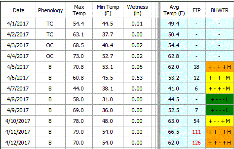
FIRE BLIGHT:
Above is a cropped graphic from the Maryblyt 7 program, using Apr 5 as the date for
first bloom open on Idared cultivar. Early-blooming cultivars still have some
susceptible bloom, and later cultivars are near full bloom in the Winchester
area. The temperature and rainfall data are current through Thursday evening,
April 20. Predicted weather conditions are shown for April 21-26. The
components of fire blight risk are indicated in the columns labeled B (blossoms
open), H (degree hours for epiphytic bacterial populations), W (wetting by rain
or dew), and T (average daily temperature 60 F or above). For infection to be
predicted, wetting must occur after the EIP (epiphytic infection potential)
reaches 100 or higher. Based on recorded temperatures and wetting, the risk column shows high risk and possible infection with
any wetting Apr 11-12, 15-18 21, 24-25 and with slightly warmer than indicated
temperatures and wetting Apr 13-14 and 18-20. Infection was indicated for Apr
12, and 15-17 and is predicted with wetting Apr 21. Note that risk can change
quickly with unpredicted warmer temperatures and wetting. In high-risk
situations, a protective streptomycin application is recommended ahead of
predicted infection. Predicted cooler temperatures should reduce risk
Apr 22-24, but will probably cause late bloom to persist into next week, and
predicted warmer temperatures Apr 26-30 (not shown) will probably again bring
high risk to late bloom. Continue to protect late bloom and bloom on newly-planted trees as needed.
The BBS column is tracking predicted
symptom development for the first infection Apr 12 and symptoms are predicted
to appear Apr 26. (Symptoms from artificial inoculation Apr 9 already appeared
at our AREC by Apr 18). The CBS column indicates progression toward the
appearance of canker margin symptoms due to extension of overwintering cankers
from last year, which would be predicted to occur when that value reaches 100
Apr 23. Canker advancement cannot be prevented by chemical treatment at this
time and the presence of symptoms will signal build-up of inoculum which could
become a factor in the event of a trauma blight/shoot blight situation due to
hail injury, etc. To offset the potential risk of shoot tip
infection in an active fire blight year such as this one, apply the plant
growth regulator, prohexadione-calcium (Apogee, Kudos), at late bloom. Shoot
blight suppression results from hardening off of vegetative shoot growth
starting about 10 days after the initial application. The fire blight
outlook will be updated Monday, Apr 24.
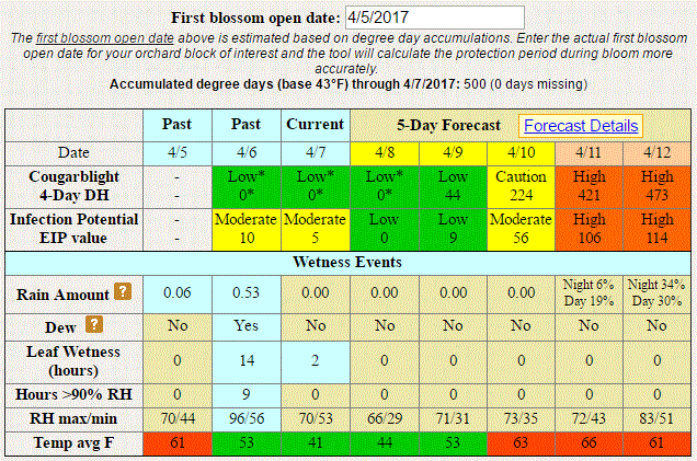
Below is the graphic
from the Cougarblight model as shown on our NEWA site. Note that we selected orchard blight history option as “Fire
blight occurred in your neighborhood last year” and first blossom open date as
4/5/2017. (This date must be re-set each time this site is accessed).
Cougarblight shows color-coded risk assessment as “Cougarblight 4-Day DH” which
was “extreme” Apr 17-19, and for today, Apr 21, and remains “high” Apr 22-23.
 |
| Cougarblight graphic for Winchester, Apr 21, 2017. Click to enlarge. |
 |
| Early blossom symptoms (center) Apr 18 from artificial inoculation Apr 9. |