NOTE: This year for fire blight risk assessment, we will be
comparing and posting graphics from Maryblyt 7 as in previous years, and also
from the Cougarblight model as shown on our NEWA site. We will be using the same weather data from our NEWA station to make these
comparisons. We thank Dr. Mizuho Nita for hosting the Maryblyt 7.1 download
site at: http://grapepathology.org/maryblyt
CAUTION: The observations,
conditions, and recommendations reported for Winchester, VA are provided as a
guide to fire blight risk assessment only for the immediate area of the
Virginia Tech AREC located six miles southwest of Winchester. Use of the
information reported here for making orchard management decisions outside of
that area is not our intent. Fruit producers outside of that area are encouraged
to consult their state extension specialists for information similar to that
provided here.
FIRE BLIGHT: Above is a cropped
graphic from the Maryblyt 7 program. We will use Saturday, Apr 14 as the date
of first bloom open on Idared and Pink Lady cultivars at our AREC. The temperature and
rainfall data are current through Wednesday evening, April 18. Predicted
weather conditions are shown for April 19-22. The components of fire blight
risk are indicated in the columns labeled B (blossoms open), H (degree hours
for epiphytic bacterial populations), W (wetting by rain or dew), and T
(average daily temperature 60°F or above). For infection to be
predicted, wetting must occur after the EIP (epiphytic infection potential)
reaches 100 or higher, and this must coincide with an average daily temperature
of 60°F or more.
Based on recorded temperatures and wetting, the risk column shows high risk for Apr 15, with an EIP of 120 and wetting from rainfall, but with rapidly dropping temperatures, the daily mean was just 57.5°F. Entering an earlier bloom date raised the EIP for Apr 15, but did not raise the risk of infection if the daily mean temperature remained at 57.5°F. However, raising the daily mean for Apr 15 to 60°F did indicate infection. With cooler predicted temperatures for the coming week or more, fire blight risk should remain low to moderate. However, with warmer than predicted temperatures, expect the risk to increase again.
Based on recorded temperatures and wetting, the risk column shows high risk for Apr 15, with an EIP of 120 and wetting from rainfall, but with rapidly dropping temperatures, the daily mean was just 57.5°F. Entering an earlier bloom date raised the EIP for Apr 15, but did not raise the risk of infection if the daily mean temperature remained at 57.5°F. However, raising the daily mean for Apr 15 to 60°F did indicate infection. With cooler predicted temperatures for the coming week or more, fire blight risk should remain low to moderate. However, with warmer than predicted temperatures, expect the risk to increase again.
Be aware that risk can change quickly with unpredicted warmer
temperatures and wetting. In high-risk situations, a protective streptomycin
application is recommended ahead of predicted infection. The fire blight outlook
will be updated Monday, Apr 23.
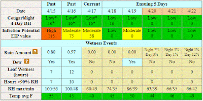
Below is the graphic from the Cougarblight model as shown on our NEWA site. Note that we selected orchard blight history option as “Fire blight occurred in your neighborhood last year” and first
blossom open date as 4/14/2017. This date should be re-checked each time the
site is accessed. Cougarblight shows color-coded risk assessment as
“Cougarblight 4-Day DH” which remains low at least through Apr 22. On the
highest risk day, the EIP in Cougarblight was 113, comparable to the value of 120
shown for Maryblyt.
 |
| Cougarblight graphic April 18, 2018. Click to enlarge. |
Scab and rust threats Apr 15-16: Fire blight is not the only disease that was marginally close to infection Apr 15. At our AREC, we recorded a wetting event of 18 hr at 41-47°, with 1.77 in. rain; ten of these hours at 41-42°. This amounted to 88% of the requirement for scab infection. Also, cedar-apple rust and quince rust spores were released during this wetting period, but it is not likely that rust infection occurred at these cool temperatures. However, where there is a concern for rust infection, it is wise to include an SI fungicide in the next spray application.
It was a different story farther south and east of the Blue Ridge, where more advanced bud stages and warmer temperatures Apr 15-16, resulted in likely infection by fire blight, apple scab and the rusts.

