Monday, April 30, 2018

High fire blight risk continues

NOTE: Many apple varieties in the Winchester area are approaching full bloom and should be near full bloom for this week's Shenandoah Apple Blossom Festival. Below are the fire blight risk assessments, comparing graphics from Maryblyt 7, and also from the Cougarblight model as shown on our NEWA site. We will be using the same weather data from our NEWA station to make these comparisons. We thank Dr. Mizuho Nita for hosting the Maryblyt 7.1 download site.

CAUTION: The observations, conditions, and recommendations reported for Winchester, VA are provided as a guide to fire blight risk assessment only for the immediate area of the Virginia Tech AREC located six miles southwest of Winchester. Use of the information reported here for making orchard management decisions outside of that area is not our intent. Fruit producers outside of that area are encouraged to consult their state extension specialists for information similar to that provided here.
Graphic from Maryblyt 7, April 30, 2018. Click to enlarge.
FIRE BLIGHT: Above is a cropped graphic from the Maryblyt 7 program. With first bloom open Apr 14. The temperature and rainfall data are current through Monday evening, April 30. Predicted weather conditions are shown for May 1-6. The components of fire blight risk are indicated in the columns labeled B (blossoms open), H (degree hours for epiphytic bacterial populations), W (wetting by rain, dew or a spray application), and T (average daily temperature 60°F or above). For infection to be predicted, wetting must occur after the EIP (epiphytic infection potential) reaches 100 or higher, and this must coincide with an average daily temperature of 60°F or more. Based on recorded temperatures and wetting, the risk column shows high risk for May 2-6. Note that all of these conditions are met except for the wetting requirement. Because a spray application can serve as the wetting trigger, consider including streptomycin with any spray application May 1-6.

Below is the graphic from the Cougarblight model as shown on our NEWA site. We selected orchard blight history option as “Fire blight occurred in your neighborhood last year” and first blossom open date as 4/14/2017. Cougarblight shows color-coded risk assessment as “Cougarblight 4-Day DH” risk is extreme for May 2-6.
Graphic from Cougarblight, April 30, 2018. Click to enlarge.
A check of NEWA stations across Virginia shows that, in general, there will be similar extreme fire blight risks wherever bloom is present, southward in the Shenandoah Valley to Roanoke, and east of the Blue Ridge from Manassas to Danville.

Any “dry weather“ day above 53° is suitable for mildew infection. So far, since Apr 10 we have had at least 13 mildew infection days at our AREC.

Saturday, April 28, 2018

Fire blight alert

NOTE: Most apple varieties in the Winchester area are at early to mid-bloom. Below are the fire blight risk assessments, comparing graphics from Maryblyt 7, and also from the Cougarblight model as shown on our NEWA site. We will be using the same weather data from our NEWA station to make these comparisons. We thank Dr. Mizuho Nita for hosting the Maryblyt 7.1 download site.

CAUTION: The observations, conditions, and recommendations reported for Winchester, VA are provided as a guide to fire blight risk assessment only for the immediate area of the Virginia Tech AREC located six miles southwest of Winchester. Use of the information reported here for making orchard management decisions outside of that area is not our intent. Fruit producers outside of that area are encouraged to consult their state extension specialists for information similar to that provided here.
Graphic from Maryblyt 7, April 27, 2018. Click to enlarge.
FIRE BLIGHT: Above is a cropped graphic from the Maryblyt 7 program. With first bloom open Apr 14. The temperature and rainfall data are current through Friday evening, April 27. Predicted weather conditions are shown for April 28-May 3. The components of fire blight risk are indicated in the columns labeled B (blossoms open), H (degree hours for epiphytic bacterial populations), W (wetting by rain or dew), and T (average daily temperature 60 F or above). For infection to be predicted, wetting must occur after the EIP (epiphytic infection potential) reaches 100 or higher, and this must coincide with an average daily temperature of 60°F or more. Based on recorded temperatures and wetting, the risk column shows high risk Apr 28, then declining to low to moderate risk for Apr 29-May 1, then high risk for May 2-3, when only the wetting requirement is lacking. Consider including streptomycin with any spray application May 1-3.

Below is the graphic from the Cougarblight model as shown on our NEWA site. We selected orchard blight history option as “Fire blight occurred in your neighborhood last year” and first blossom open date as 4/14/2017. Cougarblight shows color-coded risk assessment as “Cougarblight 4-Day DH” risk is high or extreme for May 2-3.

Wednesday, April 25, 2018

Heavy scab and rust infection period, Apr 24-25.

In Winchester, we recorded a heavy apple scab and rust infection period Apr 24-25: 30 hr at 47-56° (mean 51°), with 0.6 in. rain. Also, many cedar-apple rust and quince rust spores were released during this extended wetting period, and flowers are near their peak susceptibility for quince rust infection. In areas where there is a concern for rust infection, include an SI (DMI) fungicide in the next spray application. More wetting is expected Apr 26-27. 
Cedar apple rust galls with the spore horns fully expanded Apr 25, 2018.
Powdery mildew conidia have been available for infection at our AREC since Apr 10. Any “dry weather “ day above 53° is suitable for mildew infection. So far, we have had at least ten mildew infection days.
Fire blight: With continued predicted relatively cool temperatures in the, fire blight risk at Winchester should remain low or moderate through the weekend.

Apple scab infection conditions were similar to Winchester's southward in the Shenandoah Valley and east of the Blue Ridge, but with slightly warmer temperatures and with more than two inches of rain in some areas-- enough to erode the protective fungicide residue during the wetting event. 

Monday, April 23, 2018

Fire blight outlook this week

NOTE: Below are the fire blight risk assessments, comparing graphics from Maryblyt 7, and also from the Cougarblight model as shown on our NEWA site. We will be using the same weather data from our NEWA station to make these comparisons. We thank Dr. Mizuho Nita for hosting the Maryblyt 7.1 download site.

CAUTION: The observations, conditions, and recommendations reported for Winchester, VA are provided as a guide to fire blight risk assessment only for the immediate area of the Virginia Tech AREC located six miles southwest of Winchester. Use of the information reported here for making orchard management decisions outside of that area is not our intent. Fruit producers outside of that area are encouraged to consult their state extension specialists for information similar to that provided here.
Graphic from Maryblyt 7, April 23, 2018. Click to enlarge.
FIRE BLIGHT: Above is a cropped graphic from the Maryblyt 7 program. We are using Wednesday, Apr 14 as the date of first bloom open on Idared and Pink Lady cultivars. The temperature and rainfall data are current through Monday evening, April 23. Predicted weather conditions are shown for April 24-27. The components of fire blight risk are indicated in the columns labeled B (blossoms open), H (degree hours for epiphytic bacterial populations), W (wetting by rain or dew), and T (average daily temperature 60 F or above). For infection to be predicted, wetting must occur after the EIP (epiphytic infection potential) reaches 100 or higher, and this must coincide with an average daily temperature of 60°F or more. Based on recorded temperatures and wetting, the risk column shows low to moderate risk for Apr 23-27. With cooler predicted temperatures for the coming week or more, fire blight risk should remain low to moderate. However, with warmer than predicted temperatures, expect the risk to increase again.

Below is the graphic from the Cougarblight model as shown on our NEWA site. We selected orchard blight history option as “Fire blight occurred in your neighborhood last year” and first blossom open date as 4/14/2017. Cougarblight shows color-coded risk assessment as “Cougarblight 4-Day DH” which also remains low at least through Apr 27.
 
Cougarblight graphic from April 23, 2018. Click to enlarge.
Be aware that risk can change quickly with unpredicted warmer temperatures and wetting. In high-risk situations, a protective streptomycin application is recommended ahead of predicted infection. The fire blight outlook will be updated Friday, Apr 27.

Wednesday, April 18, 2018

Early threats by fire blight, apple scab and the rusts


NOTE: This year for fire blight risk assessment, we will be comparing and posting graphics from Maryblyt 7 as in previous years, and also from the Cougarblight model as shown on our NEWA site. We will be using the same weather data from our NEWA station to make these comparisons. We thank Dr. Mizuho Nita for hosting the Maryblyt 7.1 download site at: http://grapepathology.org/maryblyt 

CAUTION: The observations, conditions, and recommendations reported for Winchester, VA are provided as a guide to fire blight risk assessment only for the immediate area of the Virginia Tech AREC located six miles southwest of Winchester. Use of the information reported here for making orchard management decisions outside of that area is not our intent. Fruit producers outside of that area are encouraged to consult their state extension specialists for information similar to that provided here.
Maryblyt graphic April 18, 2018. Click to enlarge.

FIRE BLIGHT: Above is a cropped graphic from the Maryblyt 7 program. We will use Saturday, Apr 14 as the date of first bloom open on Idared and Pink Lady cultivars at our AREC. The temperature and rainfall data are current through Wednesday evening, April 18. Predicted weather conditions are shown for April 19-22. The components of fire blight risk are indicated in the columns labeled B (blossoms open), H (degree hours for epiphytic bacterial populations), W (wetting by rain or dew), and T (average daily temperature 60°F or above). For infection to be predicted, wetting must occur after the EIP (epiphytic infection potential) reaches 100 or higher, and this must coincide with an average daily temperature of 60°F or more. 

Based on recorded temperatures and wetting, the risk column shows high risk for Apr 15, with an EIP of 120 and wetting from rainfall, but with rapidly dropping temperatures, the daily mean was just 57.5°F. Entering an earlier bloom date raised the EIP for Apr 15, but did not raise the risk of infection if the daily mean temperature remained at 57.5°F. However, raising the daily mean for Apr 15 to 60°F did indicate infection. With cooler predicted temperatures for the coming week or more, fire blight risk should remain low to moderate. However, with warmer than predicted temperatures, expect the risk to increase again.

Be aware that risk can change quickly with unpredicted warmer temperatures and wetting. In high-risk situations, a protective streptomycin application is recommended ahead of predicted infection. The fire blight outlook will be updated Monday, Apr 23.

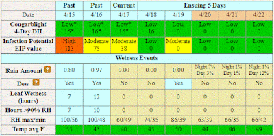
Below is the graphic from the Cougarblight model as shown on our NEWA site. Note that we selected orchard blight history option as “Fire blight occurred in your neighborhood last year” and first blossom open date as 4/14/2017. This date should be re-checked each time the site is accessed. Cougarblight shows color-coded risk assessment as “Cougarblight 4-Day DH” which remains low at least through Apr 22. On the highest risk day, the EIP in Cougarblight was 113, comparable to the value of 120 shown for Maryblyt.
Cougarblight graphic April 18, 2018. Click to enlarge.
Scab and rust threats Apr 15-16: Fire blight is not the only disease that was marginally close to infection Apr 15. At our AREC, we recorded a wetting event of 18 hr at 41-47°, with 1.77 in. rain; ten of these hours at 41-42°. This amounted to 88% of the requirement for scab infection. Also, cedar-apple rust and quince rust spores were released during this wetting period, but it is not likely that rust infection occurred at these cool temperatures. However, where there is a concern for rust infection, it is wise to include an SI fungicide in the next spray application.

It was a different story farther south and east of the Blue Ridge, where more advanced bud stages and warmer temperatures Apr 15-16, resulted in likely infection by fire blight, apple scab and the rusts.

Friday, April 13, 2018

Rapid bud development; powdery mildew, scab and rust activity

The past two days we have seen rapid apple bud development in the Winchester area. Friday morning, Apr. 13, we saw heavy powdery mildew sporulation on Idared buds at tight cluster stage. Powdery mildew infects on dry days at temperatures above 53°F, so there were several infection days this week.
Powdery mildew on Idared, Friday morning, Apr. 13, 2018.
By Friday evening, many buds were showing color at the pre-pink stage. With warm temperatures over the weekend, expect open bloom by early next week.
Pre-pink stage of Idared buds Friday evening, Apr. 13, 2018
There is a forecast for thunderstorms and rain with temperatures in the 50s Sunday and into Monday, Apr 15-16, and that would bring a scab infection period as well as our first cedar-apple and quince rust infection period in the Winchester area. 
Cedar-apple rust gall with developing spore horns Apr. 11, 2018
 Generally, the forecast is similar for the areas south to beyond Roanoke and east of the Blue Ridge, with a trend toward earlier and a shorter wetting period, but with warmer temperatures to the south. In short, scab, the rusts, and powdery mildew are now active, and there is a potential for fire blight infection in more advanced areas with open bloom.

These conditions also favor cherry leaf spot and brown rot infection with cherry trees now in bloom, and brown rot and scab on peaches in bloom or petal fall stage.

Monday, April 2, 2018

It's time!

After delayed bud development through the last two weeks of March, we saw our first green tip on Red Delicious apples at our our AREC in Winchester last week Mar 27. Apple scab ascospores were released, and we recorded 49 hr of wetting at 35-47° F with 0.5 in. of rainfall from Mar 27-29. So this was an apple scab infection period where there was enough green tissue exposed during the wetting. Over the weekend, bud development advanced as far as 1/4-in. greentip on Red Delicious by Apr 2, as shown below. Last week's wetting conditions varied somewhat east of the Blue Ridge, but it is likely that scab infection could have occurred wherever the bud stage was more advanced, from Rappahannock southward to central Virginia.
Red Delicious apple buds at Winchester April 2.
Overwintering buds infected with powdery mildew were evident at Winchester by Apr 2, and it is expected that mildew spores will be released as leaf tissue in infected buds expands and 
the leaves unroll.
Idared apple bud infected with the powdery mildew fungus (right), compared with a healthy bud (left), Apr 2. Note weaker growth and reddish appearance of emerging tissues. There would have been no indication that this was an infected bud prior to budbreak.
Powdery mildew can infect developing blossoms at pink stage and cause the mildew-russet shown below. Mildew infection occurs with dry weather during temperatures above 53° F.
Net-like russet of Jonathan apple caused by mildew infection at pink stage.